How to Use Feature Layer PTV_RestrictionZones
The Feature Layer PTV_RestrictionZones enables you to use information about restriction zones.
This layer provides Restricted transit areas for example truck transit zones. This Feature Layer contains restricted transit areas what means areas, which have special restrictions.
These restricted areas may be used by certain vehicle types, but only as start or destination otherwise they must not be passed through.
- Forbid whole areas to vehicles having a total permitted weight above a certain threshold.
- Delivery vehicles are allowed to navigate in areas that are free for delivery, but ONLY at start and destination ("At Waypoints").
- Area restrictions may be given for a certain set of vehicle types, identified through a transportSystem property
As part of the EU regulations on limits for air pollutants,
various regions and cities with high particulate air pollution installed so-called clean air and action plans,
which includes environmental zones or drive-through zones prohibiting the transit of specific types of vehicles for example trucks larger than 7.5 t.
|
FreeForDelivery zone
|
Delivery vehicle
|
Zone navigability
|
|
true
|
true
|
only in waypoints zones
|
|
true
|
false
|
no
|
|
false
|
true
|
no
|
|
false
|
false
|
no
|
Related Topics
The following topics might be relevant for this use case.
Terminology
Check these terms to ensure you understand the whole use case.
- Feature Layer
-
The Feature Layer defines the additional data mechanism. The data is partitioned into several themes that characterise different use-cases.
Benefits
PTV xRoute Server
Using PTV_RestrictionZones you can ...
PTV xMap Server
Additionally the user can easily visualise PTV_RestrictionZones data on the map using PTV xMap Server. This visualisation on the map has the following benefits for the customer:
- Improve the acceptance of a route which was calculated taking PTV_RestrictionZones into account.
Prerequisites
Check if the following prerequisites are fulfilled before you start with the use case.
-
PTV xRoute Server and a digital map of the area for route calculation.
-
Installation of Feature Layer "PTV_RestrictionZones". The usage of this Feature Layer in conjunction with PTV xRoute Server is available in version 1.18.1 or higher.
In order to request information from the feature layer theme PTV_RestrictionZones with the PTV xRoute Server, you need to ensure that the following licence key includes the theme PTV_RestrictionZones
- For PTV xRoute Server: xroute.featureLayerThemes=PTV_RestrictionZones, ...
- For PTV xMap Server: xmap.featureLayerThemes=PTV_RestrictionZones, ...
Feature Matrix for Feature Layer Restriction Zones
Find out which service method of PTV xRoute Server supports the PTV_RestrictionZones feature layer theme.
| calculateRouteInfo |
x |
| calculateRoute |
x |
| calculateExtendedRoute |
x |
| calculateTour |
x |
| calculateAdvancedTour |
x |
| calculateMatrixInfo |
x |
| calculateReachableObjects |
x |
| searchForReachableObjects |
x |
| calculateIsochrones |
x |
Concept
Feature layers are designed to provide various additional data to the user. The content depends on the feature layer theme and can be configured via XML profile. In the PTV xRoute server, feature layer data can be requested as generic FeatureDescription element for each route segment.
Installation Guide
-
Download the latest feature layer PTV_RestrictionZones from the Customer Area according to the used map. If you do not have an account, please contact your account manager at PTV.
-
Unzip the PTV_RestrictionZones_<Mapname>.zip file directly to the map folder of the PTV xRoute Server. The map folder is specified in the maps.path key of the configuration file <PTV xRoute folder>/conf/xroute.properties.
-
Restart the PTV xRoute Server to activate the just installed feature layers.
Programming Guide
Use a routing request with at least two stations defining a total permitted weight of a heavy truck and enable the use of the feature layer theme PTV_RestrictionZones by setting the following XML profile snippet in the CallerContext.
<?xml version="1.0" encoding="UTF-8" standalone="yes"?>
<Profile xmlns:xsi="http://www.w3.org/2001/XMLSchema-instance" xsi:noNamespaceSchemaLocation="http://localhost:50030/xroute/schema/XRouteProfile.xsd">
    <FeatureLayer majorVersion="1" minorVersion="0">
        <Themes>
            <Theme id="PTV_RestrictionZones" enabled="true"/>
        </Themes>
    </FeatureLayer>
    <Routing majorVersion="2" minorVersion="0">
        <Course>
            <AdditionalDataRules enabled="true"/>
        </Course>
        <Vehicle>
            <Physical>
                <Weight totalPermittedWeight="13000"/>
            </Physical>
        </Vehicle>
    </Routing>
</Profile>
 JSON sample Request: Routing with Restriction Zones
{
  "waypoints": [
    {
      "$type": "WaypointDesc",
      "linkType": "NEXT_SEGMENT",
      "fuzzyRadius": 0,
      "coords": [
        {
          "$type": "Point",
          "point": {
            "$type": "PlainPoint",
            "x": 1013303,
            "y": 6217642
          }
        }
      ]
    },
    {
      "$type": "WaypointDesc",
      "linkType": "NEXT_SEGMENT",
      "fuzzyRadius": 0,
      "coords": [
        {
          "$type": "Point",
          "point": {
            "$type": "PlainPoint",
            "x": 1031348,
            "y": 6235149
          }
        }
      ]
    }
  ],
  "options": null,
  "exceptionPaths": null,
  "details": {
    "manoeuvres": true,
    "texts": true,
    "nodes": false,
    "binaryPathDesc": false,
    "polygon": true,
    "detailLevel": "STANDARD",
    "dynamicInfo": false,
    "segments": true,
    "segmentAttributes": false,
    "manoeuvreAttributes": false,
    "brunnelManoeuvres": false,
    "urbanManoeuvres": false,
    "manoeuvreGroups": true,
    "manoeuvreGroupRatio": 1,
    "tollManoeuvres": false,
    "boundingRectanglesC": 5,
    "boundingRectanglesOffset": 300,
    "totalRectangle": true,
    "speedLimits": true
  },
  "callerContext": {
    "log1": "$TEST",
    "properties": [
      {
        "key": "ResponseGeometry",
        "value": "PLAIN,WKB"
      },
      {
        "key": "CoordFormat",
        "value": "PTV_MERCATOR"
      },
      {
        "key": "Profile",
        "value": "truckfast"
      },
      {
        "key": "ProfileXMLSnippet",
        "value": "<?xml version=\"1.0\" encoding=\"UTF-8\" standalone=\"yes\"?><Profile> <FeatureLayer majorVersion=\"1\" minorVersion=\"0\">  <Themes>   <Theme id=\"PTV_RestrictionZones\" enabled=\"true\"/>  </Themes> </FeatureLayer> <Routing majorVersion=\"2\" minorVersion=\"0\">  <Course>   <AdditionalDataRules enabled=\"true\"/>  </Course>  <Vehicle>   <Physical>    <Weight totalPermittedWeight=\"12001\"/>   </Physical>  </Vehicle> </Routing></Profile>"
      }
    ]
  }
}
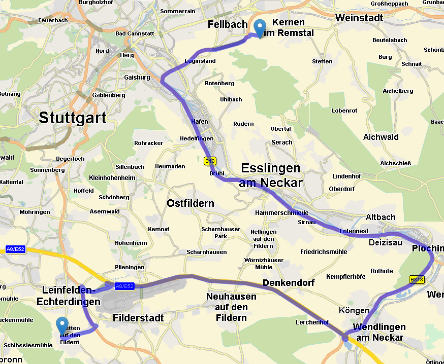
With the PTV_RestrictionZones feature layer there will be a routing result avoiding restricted zones:
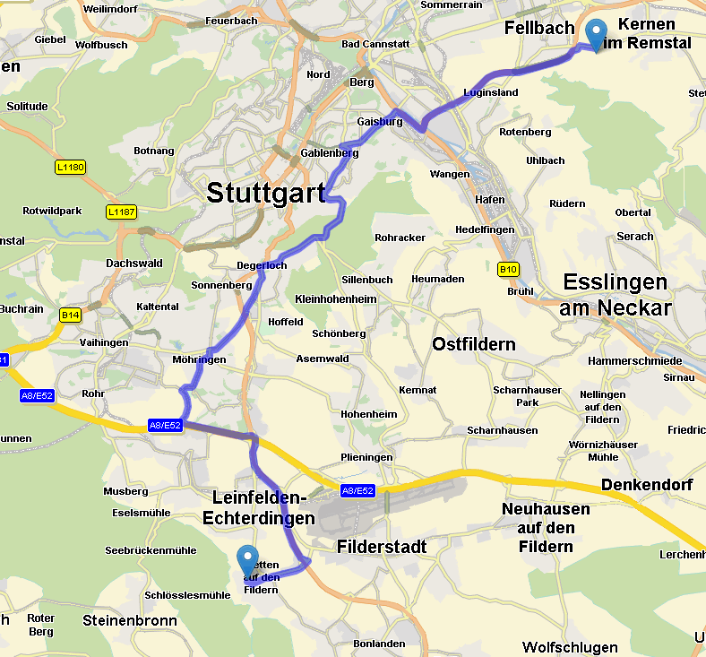
Without the PTV_RestrictionZones feature layer or with a truck with a weight of 12000 kg or below the restricted zones will be passed through:
Visualisation of PTV_RestrictionZones on the map
This section describes the general flow how to visualise PTV_RestrictionZones on the map.
Subsequent visualisation examples are just using different ProfileXMLSnippets - each of them described below - but following the same general Flow
Flow
ProfileXMLSnippet: Enabling FeatureLayer PTV_RestrictionZones
<Profile xmlns:xsi="http://www.w3.org/2001/XMLSchema-instance">
 <FeatureLayer majorVersion="1" minorVersion="0">
  <GlobalSettings enableTimeDependency="true"/>
  <Themes>
  <!-- enable the PTV_RestrictionZones theme -->
   <Theme id="PTV_RestrictionZones" enabled="true"/>
  </Themes>
 </FeatureLayer>
</Profile>
Default rendering settings for PTV_RestrictionZones
The following section shows the default rendering settings of the PTV_RestrictionZones feature layer. These settings are displayed and summarised with the associated XML snippets. Please refer to About Feature Layer Rendering for an overview of all rendering possibilities.
<Class name="TruckTransitZones">
 <Filter>
  <Condition displayClass="RestrictionZone">
   <Range values="0-200"/>
  </Condition>
 </Filter>
 <Style>
  <Geometry displayRange="9-14">
   <Stroke color="#704A4B" transparency="50" perpendicularOffset="0%" width="180%"/>
   <RenderLevel renderOffset="+10"/>
  </Geometry>
  <Geometry displayRange="15-23">
   <Stroke color="#704A4B" transparency="80" perpendicularOffset="0%" width="200%"/>
   <RenderLevel renderOffset="+10"/>
  </Geometry>
 </Style>
</Class>
The representation of the PTV_RestrictionZones is different depending on the zoom level the map is shown. On a smaller scale (DisplayRange="9-14"), restriction zones are displayed as grey lines (color=“#704A4B") with transparency (transparency="50%") and wider than the actual road (width="180%"). On a larger scale(DisplayRange="15-23") the values for transparency and width change slightly.
Be aware that a changed zoom level at DisplayRange can cause loss of performance!
Below you can find a JSON sample request which can be directly copied and put into the raw request runner of a PTV xMap Server to be tested.
JSON sample Request: Visualise Restriction Zones
{
  "mapSection": {
    "$type": "MapSection",
    "center": {
     "$type": "Point",
          "point": {
            "$type": "PlainPoint",
            "x": 1013303,
            "y": 6228442
          }
    },
    "scale": 2000,
    "scrollHorizontal": 0,
    "scrollVertical": 0,
    "zoom": 0
  },
  "mapParams": {
    "showScale": true,
    "useMiles": false
  },
  "imageInfo": {
    "format": "GIF",
    "width": 400,
    "height": 400,
    "imageParameter": ""
  },
  "layers": null,
  "includeImageInResponse": true,
  "callerContext": {
    "log1": "$TEST",
    "properties": [
      {
        "key": "CoordFormat",
        "value": "PTV_MERCATOR"
      },
      {
        "key": "ProfileXMLSnippet",
        "value": "<Profile> <FeatureLayer majorVersion=\"1\" minorVersion=\"0\"> <Themes> <Theme enabled=\"true\" id=\"PTV_RestrictionZones\"/> </Themes> </FeatureLayer> </Profile>"
      }
    ]
  }
}
Copyright © 2025 PTV Logistics GmbH All rights reserved. | Imprint