Introduction
General
The following pages explain all options for configuring the map view. The format used for the configuration settings is an ini file, separated in sections and keys. All default configuration settings are listed in a file named render.ini. The name render.ini is not obligatory. The ini file can be renamed if desired.
About this documentation
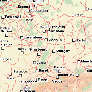
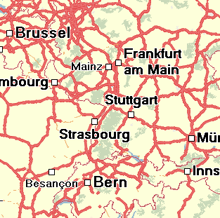
As a general rule the properties are explained in a table with two columns. The first colomn provides the configuration for the ini file. The second column shows an image, demonstrating the effect of the configuration.
Some important definitions
Explanation of colors values
The render engine uses 24 bit colors. Therefore, the red(R),green(G) and blue(B) values have a width of 1 byte each. To convert RGB values to the decimal
repesentation use the following formula:
color = R + G * 256 + B * (256*256)
Examples:
| 125 + (125*256) + (125 * 256*256) | 8224125 | grey |
| 200 + (0*256) + (200 * 256*256) | 13107400 | purple |
| 255 + (255*256) + (0 * 200*256) | 65535 | yellow |
Scale Unit
All scale values must be declared in SMartUnit/Pixel. Further explanations can be found under Explanation Scale Unit
General map properties
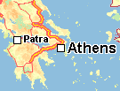
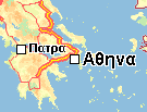
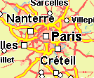
How to configure the background color.
| [map] backgroundcolor=12189439 |
First example
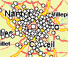
|
| [map] backgroundcolor=16306153 |
Second example
|
How to configure the fonts
All fonts used in the map are defined in the section [config.fontmap]. A font is assigned a specific identification number. For example in the table the number 0 is
assigned the font Arial with the pointsize -23.
| [config.fontmap] 0=Arial,-23,700,0,0,8,1,0,0,0, 1=Arial,-16,700,0,0,8,1,0,0,0, 2=Arial,-12,700,0,0,8,1,0,0,0, 3=Arial,-10,700,0,0,8,1,0,0,0, 4=Arial,-10,400,0,0,1,0,0,0,0, 5=Arial,-13,700,0,0,8,1,1,1,0, and so on ... |
The columns symbolize the following attributes:
| Font identification number | font name | height | bold (400 = normal, 700 = bold) | underline | italic | bpp | frame | rotable | smooth | underlined |
| 0 | Arial | -23 | 700 | 0 | 0 | 8 | 1 | 0 | 0 | 0 |
The font identification number is used for the street, background and town properties to assign a specific font. The bpp attribute only exists to ensure compatibility
with older versions.
How to configure the labeler
There are two engines for labeling. The first is the GDI Labeler, which uses the Windows GDI API to write the text. The alternative labeler uses the Freetype
engine. Freetype is available on Linux and Windows. For the Freetype labeler Truetype fonts must exist, for example Cyberbit.ttf. The GDI labeler takes the fonts from
the Windows font directory. The Freetype labeler must make the directory known to the fonts. The procedure here depends on the application.
| [config.labeler] labeler=1 |
GDI labeler
|
| [config.labeler] labeler=0 |
Freetype labeler
|
How to configure the language
The language identification numbers are listed under List of Language Codes.
The language code 0 has a special significance, it means that the default string in the map is used. The default string is always specified in the language of the
country.
| [config.street.generic] language=0 |
Default
|
| [config.street.generic] language=65 |
Greek
|
| [config.street.generic] language=51 |
French
|
How to configure the total rect
Chose the maximal possible resolution used in the renderer. The render engine defines the resolution as the real word length (in SMArtUnit) which is mapped to a single pixel. Thus the maximal possible resolution is a small number. The maximal accepted resolution is 0.0040
How to configure the smooth
Turn off/on the smoothing of all geometrical objects, i.e. lines and polygons. If turned off, small stairs may appear in the display of geometrical objects especially at small scales. Font antialiasing is not affected by this option.
| [map] smooth=true |
|
| [map] smooth=false |
|
How to configure the maximal resolution
Chose the maximal possible resolution used in the renderer. The render engine defines the resolution as the real word length (in SMArtUnit) which is mapped to a single pixel. Thus the maximal possible resolution is a small number. The maximal accepted resolution is 0.0040 SMartUnit/Pixel.
Town map properties
The town properties are dependent on town category. A list of town categories can be found under List of town categories. Towns are displayed on the map through two parts, the text (called town name) and the symbol (called town symbol).
How to configure the town font and town font color.
The possibilities to setting the town font and town font color are very flexible. Either can be configured in relation to the scale range. The map is divided into different scale ranges. A scale range can be from 4 to 10 SMartUnit/Pixel and so on. The scale ranges are listed in the section [config.townregions]. The key number declares the quantity of scale ranges. The keys from 0 to 9 are assigned a scale value in SMartUnit/Pixel.
| [config.townregions] number=11 0=4.000000 1=10.000000 2=16.000000 3=20.000000 4=50.000000 5=100.000000 6=200.000000 7=350.000000 8=1000.000000 9=5000.000000 |
11 town regions |
In the section [config.townfonts] the font for a special scale range is set, which is described in [config.townregions]. The keys from 0 to 15 symbolize the town
category. The values symbolize the font identification number in the section [config.fontmap].
| [config.townfonts] 0=16,16,16,16,15,15,13,13,12,2,2, 1=16,16,16,16,15,15,12,12,2,3,3, 2=16,16,15,15,14,13,12,1,10,9,9, 3=16,16,15,15,13,12,1,11,0,0,0, 4=16,15,14,13,12,11,2,10,0,0,0, 5=15,14,14,13,1,2,10,9,0,0,0, 6=15,14,13,12,11,10,0,0,0,0,0, 7=14,13,12,1,2,9,0,0,0,0,0, 8=13,12,1,11,10,0,0,0,0,0,0, 9=12,1,11,2,9,0,0,0,0,0,0, 10=12,1,11,2,9,0,0,0,0,0,0, 11=12,11,2,10,9,0,0,0,0,0,0, 12=12,2,10,9,0,0,0,0,0,0,0, 13=12,2,10,9,0,0,0,0,0,0,0, 14=12,2,10,9,0,0,0,0,0,0,0, 15=12,10,9,9,0,0,0,0,0,0,0, |
|
The table must be read so: In the scale range from 0 to 4 the town font with the identification number 16 is used for town names with the category 0.
In the section [config.townfontscolor] the font color for a special scale range is set, which is described in [config.townregions]. The keys from 0 to 15 symbolize
the town category. The values symbolize the color value which is described in Declaration Of Color Values.
| [config.townfontscolor] 0=0,0,0,0,0,0,0,0,0,0,255, 1=0,0,0,0,0,0,0,0,0,0,0, 2=0,0,0,0,0,0,0,0,0,0,0, 3=0,0,0,0,0,0,0,0,0,0,0, 4=0,0,0,0,0,0,0,0,0,0,0, 5=0,0,0,0,0,0,0,0,0,0,0, 6=0,0,0,0,0,0,0,0,0,0,0, 7=0,0,0,0,0,0,0,0,0,0,0, 8=0,0,0,0,0,0,0,0,0,0,0, 9=0,0,0,0,0,0,0,0,0,0,0, 10=0,0,0,0,0,0,0,0,0,0,0, 11=0,0,0,0,0,0,0,0,0,0,0, 12=0,0,0,0,0,0,0,0,0,0,0, 13=0,0,0,0,0,0,0,0,0,0,0, 14=0,0,0,0,0,0,0,0,0,0,0, 15=0,0,0,0,0,0,0,0,0,0,0, |
|
The table must be read so: In the scale range from 0 to 4 the town font color 0 (black) is used for town names with the category 0.
How to configure the visibility from town names in dependent from scale
In the section [config.town.namethreshold] the visibility of towns can be configured in relation to the scale in SMartUnit/Pixel. The visibility can be set per town category.
| [config.town.namethreshold] 0=50000.000000 1=4000.000000 2=1500.000000 3=500.000000 4=350.000000 5=200.000000 6=100.000000 7=70.000000 8=50.000000 9=30.000000 10=25.000000 11=22.000000 12=20.000000 13=19.000000 14=19.000000 15=18.000000 |
The table must be read so: A town with the category 3 is displayed in a scale range from 0 to 500 SMartUnit/Pixel and so on...
How to configure the visibility of town names and town symbols.
In the section [config.town.visible] the town names and the town symbols can be switched to not visible or visible. This switch is valid for all scale ranges.
| [config.town.visible] name=false |
Town symbols and names are not visible.
|
How to control the visibility of town symbols depending on scale
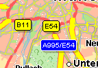
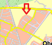
The key townsymbolsnever controls the scale at which the town symbols are visible. In the example the key townsymbolsnever is assigned a value from 300 SMartUnit/Pixel. This means that in the scale range from 0 to 300 SMartUnit/Pixel the town symbols are not visible.
| [config.town.symbols] townsymbolsnever=300.0 |
Town symbols are not visible at a current scale from 246 SU/Pixel.
|
How to configure town symbols.
How to configure the type of town symbols.
There are different options when configuring the type of town symbols:
- 0 for rectangle
- 1 for circle
- 2 for cross
- 3 for ADAC atlas
- 4 for circles with and without an inner black circle and a rectangle (depending on the category).
| [config.town.symbols] symbolkind=4 |
|
| [config.town.symbols] symbolkind=3 |
|
| [config.town.symbols] symbolkind=2 |
|
How to configure the fill and frame color of town symbols
| [config.town.symbols] symbolcolor=14075112 symbolframecolor=13107200 |
|
How to configure the size of town symbols
The key symbolsizemin sets the minimal possible extension in pixel which a town symbol can have. The key symbolsizemax sets the maximal possible extension in pixels which a town symbol can have. The width of town symbols cannot fall below the value of symbolsizemin. The width of town symbols cannot pass over the value of symbolsizemax.
| [config.town.symbols] symbolsizemin=8 symbolsizemax=18 |
|
How to show postcodes together with the townname
The key showpostcode controls the visibility from postcodes. If it set to true the postcode is displayed together with the town name.
| [config.town.symbols] showpostcode=true |
|
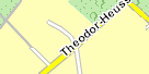
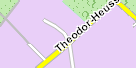
How to control the linefeed for longer town names
There are town names which contain white spaces or hyphens. These town names are displayed in multiple lines. With the key minimumcharacters the minimum number of characters before the line can be controlled.
| [config.town.symbols] minimumcharacters=5 |

|
| [config.town.symbols] minimumcharacters=8 |
|
How to display town symbols only, if town names are also shown
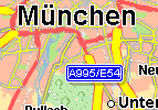
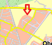
The key townSymbolOnlyIfNameIsDrawn controls the town symbols which are drawn only if the town names are drawn. For example if the key townSymbolOnlyIfNameIsDrawn has the value 200 SMartUnit/Pixel then the town symbols are always drawn in the scale range from 0 to 200 SMartUnit/Pixel. Up to a scale greater than 200 SMartUnit/Pixel, town symbols are only drawn if town text is drawn.
| [config.town.symbols] townSymbolOnlyIfNameIsDrawn=0.0 |
Current scale is 154 SU/Pixel.
|
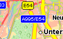
| [config.town.symbols] townSymbolOnlyIfNameIsDrawn=200.0 |
Current scale is 154 SU/Pixel.
|
How to control the frequency and density of town texts in the map
There are several keys to control this:
- symboltextadditionalspace
- symboltextcheckspace
- TextReservationRanges
- TextAdditionalSpaces
- TextCheckSpaces
Warning: The keys symboltextadditionalspace and symboltextcheckspace are only supported if the keys TextReservationRanges, TextAdditionalSpaces and TextCheckSpaces are not found in the ini file. The keys TextReservationRanges, TextAdditionalSpaces and TextCheckSpaces are newer than symboltextadditionalspace and symboltextcheckspace. The keys symboltextadditionalspace and symboltextcheckspace are valid for all scale ranges in the map. The keys TextReservationRanges, TextAdditionalSpaces and TextCheckSpaces support the option of making settings contrary to a specific scale range. This is the reason that older ini files which do not contain the keys TextReservationRanges, TextAdditionalSpaces and TextCheckSpaces must be supported without any changes.
| [config.town.symbols] TextReservationRanges=1000.000000,2000.000000, |
With the key TextReservationRanges the map is divided into scale ranges. The values are the scale in the unit SMArtUnit/pixel. The values are comma separated. The correct order is from a smaller scale to a higher scale, for example TextReservationRanges=400,1000. |
| [config.town.symbols] TextAdditionalSpaces=2,5,5, |
The key TextAdditionalSpaces defines widths in pixels, which are added to the reserved space for town texts. The values are comma separated. The assignment of values in TextAdditionalSpaces to values in TextReservationRanges is from left to right. This implies for example that the pixel value 2 belongs to the scale range smaller than 1000 SMArtUnit/pixel and so on. |
| [config.town.symbols] TextCheckSpaces=5,15,10, |
The key TextCheckSpaces defines widths in pixels, which are added to the check space for town texts. This setting does not influence the size of the text boxes. The values are comma separated. The assignment of values in TextCheckSpaces to values in TextReservationRanges is from left to right. This implies for example that the pixel value 5 belongs to the scale range smaller than 1000 SMArtUnit/pixel and so on. |
Street map properties
General informations about street configuration
Street properties are dependent on street type and street category. A list of street types can be found under List of street types. A list of street categories can be found under List of street categories.
The following properties are dependent on street category:
- Visibility of streets
- Visibility of street names
- Fonts for street names
- Colors for street names
- Visibility of oneways
Attention! Unfortunately, the street types are not consistent. For some sections the values are numbered starting from 0, for others they are numbered
starting from 1. In the table below, this in indicated by the numbers in brackets.
The following properties are dependent on street type:
- Fill- and framecolor (starting at 0)
- Street width in pixel (starting at 1)
- Visiblity of street signs (starting at 1)
How to configure the street width
The street width can be configured in relation to the scale range. The map is divided in different scale ranges. A scale range can be from 4 to 20 SMartUnit/Pixel and so on. The scale ranges are listed in the section [config.street.width.regions]. The key number declares the quantity of scale ranges. The keys from 0 to 15 is assigned a scale value in SMartUnit/Pixel.
| [config.street.width.regions] number=16 0=0.050000 1=0.075000 2=0.100000 3=0.150000 4=0.200000 5=0.250000 6=0.500000 7=1.000000 8=2.000000 9=4.000000 10=8.000000 11=16.000000 12=32.000000 13=64.000000 14=150.000000 15=200.000000 |
16 street regions |
In the section [config.street.width] is defined the street width in pixel. The keys from 1 to 15 symbolize the street type. The columns symbolize the scale range.
| [config.street.width] 1=3,4,4,6,8,8,9,10,11,12,14,18,22,26,30,34 2=1,2,2,3,4,5,6,7,9,10,13,17,21,25,29,33 3=1,1,2,2,3,4,5,6,9,9,13,17,21,25,29,33 4=1,1,2,3,3,4,5,6,9,9,13,17,21,25,29,33 5=1,1,2,3,3,3,4,5,6,8,10,14,18,22,26,30 6=1,1,1,1,1,1,1,3,4,6,8,12,16,20,24,28 7=1,1,1,1,1,1,1,1,1,1,1,1,1,1,1,1 8=0,0,0,0,0,0,1,2,3,5,7,11,15,19,23,27 9=0,0,0,0,0,0,1,1,2,3,4,8,12,5,5,5 10=0,0,0,0,0,0,1,3,3,6,8,10,10,10,10,10 11=0,0,0,0,0,0,1,3,3,6,8,10,10,10,10,10 12=0,0,0,0,0,0,1,3,3,6,8,10,10,10,10,10 13=0,0,0,0,0,0,1,3,3,6,8,10,10,10,10,10 14=0,0,0,0,0,0,1,3,3,6,8,10,10,10,10,10 15=0,0,0,0,0,0,1,3,3,6,8,10,10,10,10,10 |

|
The tables must be read so: In the scale range from 0 to 0.05 the street width type 1 is displayed with 34 pixels.
In the scale range from 0.05 to 0.075 the street width type 1 is displayed with 30 pixels.
and so on...
| SMartUnit/Pixel | 0-0.05 | 0.05-0.075 | 0.075-0.1 | 0.1-0.15 | 0.15-0.2 | 0.2-0.25 | 0.25-0.5 | 0.5-1.0 | 1.0-2.0 | 2.0-4.0 | 4.0-8.0 | 8.0-16.0 | 16.0-34.0 | 34.0-150 | 150-200 | 200 |
| Street type 1 (All values in pixel.) |
34 | 30 | 26 | 22 | 18 | 14 | 12 | 11 | 10 | 9 | 8 | 8 | 6 | 4 | 4 | 3 |
How to configure the street color
The street color depends ons the street type List of street types. There are the fill color and the frame
colors. The fill colors can be configured in the section [config.streeti.colorbytype]. The frame colors can be configured in the section
[config.streetf.colorbytype].
Here are two different ways, to do it.
| [config.streeti.colorbytype] 0=65535 1=5921535 2=5921535 3=65535 4=65535 ... |
[config.streetf.colorbytype] 0=5921535 1=5921535 2=5921535 3=10526880 4=12040119 ... |
Example 1
|
| [config.streeti.colorbytype] 0=6750207 1=9487092 2=9487092 3=11269364 4=11269364 ... |
[config.streetf.colorbytype] 0=5460966 1=6859758 2=6859758 3=12369086 4=12369086 ... |
Example 2
|
How to configure the visibility of streets
The section [config.street.threshold] controls the visibility of the streets depending on the scale. The keys refer to the street category. Note that level 6 and 7 are overview levels which do not contain street names. The unit is Smartunit/Pixel.
| [config.street.threshold] 1=1000.000000 2=300.000000 3=50.000000 4=35.000000 5=15.000000 6=4.000000 7=4.000000 8=2.000000 |
Par example:
| Line 1=1000.0 means that all streets with category 1 are visible in the scale range from 0 to 1000.0 Smartunit/Pixel. |
| Line 2=300.0 means that all streets with category 2 are visible in the scale range from 0 to 300.0 Smartunit/Pixel. |
How to configure the visibility of street names
The section controls the visibility of the street names depending on the scale. The keys refer to the street category.
| [config.street.namethreshold] 1=12.000000 2=8.000000 3=6.000000 4=5.000000 5=3.000000 6=2.000000 7=1.500000 8=1.500000 |
How to configure the width of inner street lines
The section [config.street.innerstreetline] sets the pixel width of the inner street lines.
| [config.street.innerstreetline] ; ; Maximal width for the inner street line. ; innerstreetlinewidthswitch=20 ; ; The number of pixels which is subtracted from the street lines that are smaller ; than the street widths from innerstreetlinewidthswitch ; lowerpixeldelta=2 ; ; The number of pixels which are subtracted from the street lines that are wider ; than the street widths from innerstreetlinewidthswitch ; upperpixeldelta=6 |
How to configure the street signs
General Properties in section [config.sign]
The key doubleframe toggles the double frame from a sign.
| [config.sign] doubleframe=false |
Double frame is false
|
[config.sign] doubleframe=true |
Double frame is true
|
The key font is assigned a font ID, which is defined in the section [config.fontmap]
| [config.sign] signs=4 |
|
The key shadow toogles the shadow from a sign.
| [config.sign] shadow=false |
Shadow is false
|
[config.sign] shadow=true |
Shadow is true
|
The key transparency defines the intensity of the shadow under the sign.
| [config.sign] transparency=20 |
|
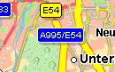
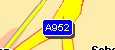
The key maxsigntype defines from which street type the street labels are displayed as signs. A list of street types can be found under List of street types.
| [config.sign] maxsigntype=3 |
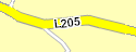
All labels from street types bigger than 3 are displayed as simple text.
|
[config.sign] maxsigntype=6 |
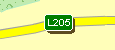
All lables from street types till 6 are displayed as signs.
|
Signs Colors in section [config.sign.international]
The fill- and fontcolor can be configured in relation to the country. A list of the country codes can be found under List of Country Codes.
There are three keywords (countrycode, signbackgroundcolor, signfontcolor) which determine the colors of signs. Each keyword ends with a number. All keys are numbered in ascending order. A special number is 0. The keywords which end with the number 0 define the default configuration. The default configuration is used for all countries for which no special configuration is defined. For the following countries special configurations exist.
The key countrycodeXY is assigned the country code. The keys signbackgroundcolor and signfontcolor define the colors. signbackgroundcolor and signfontcolor are assigned 8 colors.
| Street type | 0 | 1 | 2 | 3 | 4 | 5 | 6 | 7 |
| Color (signbackgroundcolor) for country Germany |
16777215 | 16711680 | 65535 | 65535 | 32512 | 16777215 | 16777215 | 0 |
| Color (signfontcolor) for country Germany |
0 | 16777215 | 0 | 0 | 16777215 | 0 | 16711680 | 0 |
Signs Visibility in section [config.signthreshold]
The sign visibility is configurted in the section [config.signthreshold]. The first number corresponds to the street type. Each street type is assigned a value in
SMartUnit/Pixel. The table must be read as follows:
For streets from type 1 the signs will be displayed below scale of 100 SMartUnit/Pixel.
For streets from type 4 the signs will be displayed below scale of 4 SMartUnit/Pixel.
How to configure the sign main node
Main nodes are central points on highway connectors or highway junctions.
| [config.sign.mainnode] showMainNode=2.000000 |
Main node labels are displayed below this threshold.
|
| [config.sign.mainnode] shortName=true |
Main node is displayed as short name.
|
How to configure the house numbers
The section [config.housenumbers] determines some house number properties.
How can I switch the visibility of streets and street names separately from each other?
| [config.street.visible] ; ; Display of names ; name=false ; ; Display of lines marking streets ; line=true |
Street names, signs and housenumbers are not visible.
|
| [config.street.visible] ; ; Display of names ; name=true ; ; Display of lines marking streets ; line=false |
Street lines are not visible.
|
How to configure the visibility of one-way symbols?
The visibility of one-way symbols is configurable per street category.
| [config.street.onewaythreshold] 1=0.50 2=0.00 3=0.00 4=0.25 5=0.25 6=0.00 7=0.00 8=0.00 |
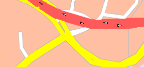
Scale: 0.45 SMartUnit/Pixel.
|
The one-way symbols of streets with the category 1 are visible. |
| [config.street.onewaythreshold] 1=0.50 2=0.00 3=0.00 4=0.50 5=0.50 6=0.00 7=0.00 8=0.00 |
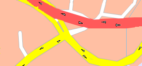
Scale: 0.45 SMartUnit/Pixel.
|
The one-way symbols of streets with the category 1, 4 and 5 are visible. |
How to thin out street segments?
The section [config.street.generalization] provides the possibility to thin out street segments depending on the scale range and the street segment lengths in pixels.
Description of the keys.
| number=2 | Number of scale ranges to divide the map in different sections. |
| 0=100 | Two scale ranges are defined. The first scale range defines the interval from 0 to 100 SMartUnit/Pixel. The second scale range defines the interval from 100 SMartUnit/Pixel to endless. |
| length=0,8 | Street length in pixels. In the first scale range no street segments are filtered out, because the pixel length is set to 0. In the second scale range all street segments with the length from 8 pixels are filtered out. |
Examples
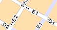
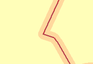
| [config.street.generalization] number=1 0=0 length=0 |
Scale: 163 SMartUnit/Pixel.
|
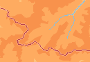
No street segments are filtered out. The real street gradient is visible. |
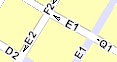
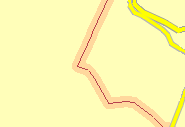
| [config.street.generalization] number=2 0=100 length=0,10 |
Scale: 163 SMartUnit/Pixel.
|
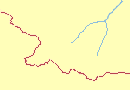
In the scale range from 100 SMartUnit/Pixel to endless all street segments are filtered out with a length from 10 pixels. |
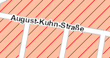
| [config.street.generalization] number=2 0=100 length=0,10 |
Scale: 1.8 SMartUnit/Pixel.
|
In the scale range from 0 SMartUnit/Pixel to 100 no street segments are filtered out. |
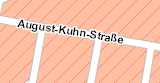
| [config.street.generalization] number=2 0=100 length=10,12 |
Scale: 1.8 SMartUnit/Pixel.
|
In the scale range from 0 SMartUnit/Pixel to 100 all street segments are filtered out with a length from 10 pixels. |
How to thin out road number signs?
The section [config.roadnumbergrid] allows to configure how many road number signs are displayed. To avoid that road number signs with the same name are displayed next to each other, the rendering algorithm uses an invisible grid. If two or more signs with the same name are in the same grid cell, only one of those is displayed, all others are hidden.
You can configure the size of this grid in the following way:
Description of the keys.
| regions=8.0,15.0,22.0 | This example defines 4 ranges from scale=0 to 8, from 8 to 15, from 15 to 22 and from 22 to infinity. |
|
cellheight=180,160,140,100
cellwidth=100,140,160,180
|
These two lines specify the width and height of the grid cells in pixels. The four values in the example correspond to the four scale ranges defined above, i.e. e.g. in the second scale range from 8 to 15 SU/pixel, the grid cells will be 140 pixels wide and 160 pixels high. |
Examples
|
[config.roadnumbergrid]
regions=99999.0
cellheight=100
cellwidth=100
|
scale 60 SU/pixel, grid 100x100 pixel.
|
There is only one range, where the grid cells are always 100 x 100 pixels. |
|
[config.roadnumbergrid]
regions=10.0
cellheight=100,150
cellwidth=100,150
|
scale 60 SU/pixel, grid 450x450 pixel.
|
There are two scale ranges, one below, the other above a scale of 10 SU per pixel. Below scale 10, cells have a size of 100 pixel, above they are 150 pixel wide. |
Background map properties
The background types are listed under List of background types
Currently there are 32 area-shaped background types and four line shaped background types. Each background type has a definite identification number. The area-shaped
background types are assigned the numbers 0 to 31. The line-shaped background types are assigned the numbers 32 to 35.
The configuration for the background areas all function according to the same principle. A specific background type number is assigned a specific property.
The following properties can be configured:
How to configure the building frame size?
The frame is only supported for buildings in the *.bdg and *.bdb files.
A list of building types, which support the frame can be found here.
| [config.background] BuildingFrameSize=1 |
BuildingFrameSize with one pixel.
|
| [config.background] BuildingFrameSize=4 |
BuildingFrameSize with four pixels.
|
How to configure the font size for background areas?
The font index is listed in the section [config.fontmap]. This font is used for all background names.
Fillcolor in section [config.background.colorbytype]
| [config.background.colorbytype] 6=255 |
Red fillcolor for Built-up areas
|
What is the border width factor?
The key borderwidthfactor key is multiplied by the border width. If you set the value borderwidthfactor=2.0, the border width is multiplied with 2.
| [config.background] borderwidthfactor=1.0 |
The key borderwidthfactor is 1.0.
|
| [config.background] borderwidthfactor=5.0 |
The key borderwidthfactor is 5.0.
|
| [config.background] borderwidthfactor=10.0 |
The key borderwidthfactor is 10.0.
|
Framecolor in section [config.backgroundframe.colorbytype]. Only possible for building types.
This table gives an overview of background types for which the frame color can be set.
| Background Type Number | Background Description | Frame is supported. |
|---|---|---|
| 0 | Not in use | No |
| 1 | Woodland | No |
| 2 | Named location; address area | No |
| 3 | Traffic feature | No |
| 4 | Traffic feature; airport | No |
| 5 | Pedestrian zone | No |
| 6 | Built-up area | No |
| 7 | Water | No |
| 8 | Ocean | No |
| 9 | Traffic feature; aircraft Roads | No |
| 10 | Parks and green areas | No |
| 11 | Commercial | Yes |
| 12 | Public building | Yes |
| 13 | Public building; cultural | Yes |
| 14 | Residential | Yes |
| 15 | Sport and leisure | Yes |
| 16 | Reservation | No |
| 17 | Public building; medical | Yes |
| 18 | Public Building; educational | Yes |
| 19 | Military base | Yes |
| 20 | Comprehensive - industry | No |
| 21 | Comprehensive - cemetery | No |
| 22 | Beach, dune and sand plain | No |
| 23 | Park in water | No |
| 24 | Moors and heathland | No |
| 25 | Comprehensive - sports complex | No |
| 26 | Comprehensive - golf | No |
| 27 | Comprehensive - university/college, - hospital | No |
| 28 | Comprehensive - Shopping center | No |
| 29 | Green zone, green | No |
| 30 | Green zone, yellow | No |
| 31 | Green zone, red | No |
| 32 | River | No |
| 33 | Rail | No |
| 34 | Country border | No |
| 35 | Federal border | No |
| [config.backgroundframe.colorbytype] ; Public building; cultural 13=8421631 |
Frame color for cultural buildings.
|
Hatch in section [config.background.hatch]
There are 7 values in the range from 0 to 6 to configure the hatch type.
- 0 No hatch
- 1 Horizontal hatch
- 2 Vertical hatch
- 3 45-degree downward left-to-right hatch
- 4 45-degree upward left-to-right hatch
- 5 Horizontal and vertical crosshatch
- 6 45-degree crosshatch
| [config.background.hatch] 6=6 |
Hatch for Built-up area, 45-degree crosshatch
|
Hatchcolor in section [config.background.hatchcolor]
| [config.background.hatchcolor] 6=255 |
Red Hatchcolor for Built-up area
|
Transparency in section [config.background.alphablending]
The alphablending values are declared in percent.
- 0% means the color is opaque
- 100% means the color is not visible
| [config.background.alphablending] ; Built-up area 6=0 |
|
| [config.background.alphablending] ; Built-up area 6=50 |
|
| [config.background.alphablending] ; Built-up area 6=100 |
|
Transparency of the hatch in a section[config.background.alphablending.hatch]
The alphablending values are declared in percent.
- 0% means the color is opaque
- 100% means the color is not visible
| [config.background.alphablending.hatch] ; Built-up area 6=0 |
|
| [config.background.alphablending.hatch] ; Built-up area 6=70 |
|
| [config.background.alphablending.hatch] ; Built-up area 6=100 |
|
Global Visibility in section [config.background.threshold]
In this section the global visibility of backgrounds is toggled.
| [config.background.threshold] ; Green zone, red 31=true |
|
| [config.background.threshold] ; Green zone, red 31=false |
|
Visibility of backgroundnames dependant on scale in section [config.background.namethreshold]
Sets the scale in SMartUnit/Pixel below which a background name is visible.
| [config.background.namethreshold] ; Woodland 1=1.300000 |
|
Bitmap in section [config.background.patternbytype]
There are two possibilities to configure background patterns:
- 1. Patterns could be given directly as bitmaps (bmp). In this case the pattern could be read directly. The syntax is key=filename like 1=woodland.bmp. The file should be located in the same directory as the executable, or the name including path could be set in the application.
- 2. The bitmap pattern could be base64 encoded (transformed to an ASCII string) and then directly written to the configuration file. Here the syntax: 1-b64-key=string must be used.
Possibility 1
| [config.background.patternbytype] 1=woodland.bmp |
Possibility 2
|
[config.background.patternbytype] |
Take attention to the fact that the load of a rendering profile is slower through a very big base64 encoded string. The number of string lines should not be more than 100 - 150 lines. A greater number of lines are possible, but the load of the profile will get much slower.
How does the country dependent background configuration function?
In the section [config.background.countrycode] all countries are listed for which a special background configuration exist. A list of the country codes can be found under List of Country Codes.
A key entry can be:
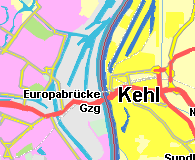
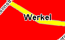
Built-up and water areas at Strasbourg and Kehl.
|
There are two exceptions where country dependent background configuration does not function:
- Borders with the key 34, 35.
- Line style for rails with the key 33.
How to configure the width of borders, rails and rivers?
In the [config.background.region.width] section the width of line shaped areas is specified depending to the scale range. The number key sets the number of regions, in which the area has a different width. The regions key sets the scale ranges. The width key sets the width of the areas which has a line shape. The last digit of the keys number, width and regions refer to the area type.
- Area type 32: River
- Area type 33: Rail
- Area type 34: Country border
- Area type 35: Federal border
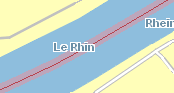
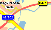
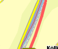
Border width at scale 1.5. Width with 10 pixels.
|
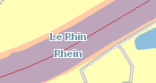
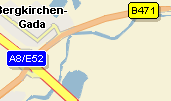
Border width at scale 2.5. Width with 50 pixels.
|
How to configure the width of inner lines of borders?
In the [config.background.region.width.inner] section the width of inner lines of line shaped areas is specified depending on the scale range. For example the
borders are displayed with an inner line. The number key sets the number of regions, in which the area has a different width. The regions key sets the scale ranges.
The width key sets the width of the areas which have a line shape. The key names end with the area type number.
This configuration is only supported for borders with the area type 34 and 35.
- Area type 34: Country border
- Area type 35: Federal border
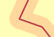
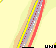
Federal border at scale 0.3. Width is 5 pixels.
|
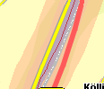
Federal border at scale 0.8. Width is 2 pixels.
|
Federal border at scale 2.0. Width is 1 pixel.
|
How to configure the line style of rails?
|
[config.background.linestyle] [config.background.colorbytype] |
|
|
[config.background.linestyle] [config.background.colorbytype] |
|
Height map properties
The height types are listed under List of height types
The configuration of heights all function according to the same principle. A specific height type number is assigned a specific property.
The following properties can be configured:
Fillcolor in section [config.height.colorbytype]
| [config.height.colorbytype] ; Elevation between 1000m and 1500m 24=6335486 ; Elevation between 1500m and 2000m 26=5018360 |
Fillcolor for height
|
Hatchcolor in section [config.height.hatchcolor] and the hatch in section [config.height.hatch]
There are 7 values in the range from 0 to 6 to configure the hatch type.
- 0 No hatch
- 1 Horizontal hatch
- 2 Vertical hatch
- 3 45-degree downward left-to-right hatch
- 4 45-degree upward left-to-right hatch
- 5 Horizontal and vertical crosshatch
- 6 45-degree crosshatch
| [config.height.hatchcolor] ; Elevation between 1000m and 1500m 24=16711680 ; Elevation between 1500m and 2000m 26=255 |
[config.height.hatch] ; Elevation between 1000m and 1500m 24=1 ; Elevation between 1500m and 2000m 26=6 |
Hatch for height
|
Global visibility in section [config.height.threshold]
| [config.height.threshold] ; Elevation between 1000m and 1500m 24=false ; Elevation between 1500m and 2000m 26=false |
Visibility is false
|
| [config.height.threshold] ; Elevation between 1000m and 1500m 24=true ; Elevation between 1500m and 2000m 26=true |

Visibility is true
|
Examples of rendering profiles.
| Profile Standard | Profile Alternative 1 | Profile Alternative 2 |
|---|---|---|
|
|
|
F.A.Q.
How can I make the green zones visible?
| [config.background.threshold] ; Green zone, green 29=true ; Green zone, yellow 30=true ; Green zone, red 31=true |
Why can I not see my signs colors for another country?
Configuring the sign colors is described under Signs Colors. You can add signs colors for a further country, for example Czech Republic, like this:
If this does not function, control the following points:
- The country code must be correct. A list of country codes can be found here..
- The number of keys must be continuous!
Right:
|
[config.sign.international] |
Wrong:
| [config.sign.international] ; default countrycode0=0 signbackgroundcolor0=16777215,16711680,65535,65535,32512,16777215,16777215,0 signfontcolor0=0,16777215,0,0,16777215,0,16711680,0 ; Belgium countrycode1=32 signbackgroundcolor1=16777215,16777215,15638095,15638095,32512,16777215,16777215,0 signfontcolor1=0,0,16777215,16777215,16777215,0,16711680,0 ;Czech Republic countrycode18=1 signbackgroundcolor18=16777215,255,4456548,4456548,32512,16777215,16777215,0 signfontcolor18=0,16777215,16777215,16777215,16777215,0,16711680,0 |