
xload


planZoneLoading
| Parameter Name | Type | Description |
|---|---|---|
vehicleConfiguration
|
VehicleConfiguration
|
Configuration of the vehicle loading space (required). |
transportUnits
|
TransportUnit[]
|
Potential transport units to load. If it is not possible to load all transport units, the units are selected randomly (required). |
responseContents
|
ResponseContents
|
Options to configure the contents of the response (optional). |
| Return Type | Description |
|---|---|
ZoneLoadingPlan
|
Plan that describes how to configure and load a multi zone vehicle. |
XLoadException
|
Thrown if an xLoad server exception such as an invalid request parameter occurs. |
XServiceException
|
Thrown if a PTV xServer framework exception occurs. |
startPlanZoneLoading
| Parameter Name | Type | Description |
|---|---|---|
vehicleConfiguration
|
VehicleConfiguration
|
Configuration of the vehicle loading space (required). |
transportUnits
|
TransportUnit[]
|
Potential transport units to load. If it is not possible to load all transport units, the units are selected randomly (required). |
responseContents
|
ResponseContents
|
Options to configure the contents of the response (optional). |
| Return Type | Description |
|---|---|
Job
|
The Job reference. |
XLoadException
|
Thrown if an xLoad server exception such as an invalid request parameter occurs. |
XServiceException
|
Thrown if a PTV xServer framework exception occurs. |
fetchZoneLoadingPlan
| Parameter Name | Type | Description |
|---|---|---|
id
|
String
|
The id of the job. |
| Return Type | Description |
|---|---|
ZoneLoadingPlan
|
Plan that describes how to configure and load a multi zone vehicle. |
XLoadException
|
Thrown if an xLoad server exception such as an invalid request parameter occurs. |
XServiceException
|
Thrown if a PTV xServer framework exception occurs. |
watchJob
| Parameter Name | Type | Description |
|---|---|---|
id
|
String
|
The id of the job. |
watchOptions
|
WatchOptions
|
The options to control job status and progress updates. |
| Return Type | Description |
|---|---|
Job
|
The job reference. |
SystemException
|
Thrown if job management is not available, for example if it is misconfigured. |
stopJob
| Parameter Name | Type | Description |
|---|---|---|
id
|
String
|
The id of the job to be stopped. |
| Return Type | Description |
|---|---|
Job
|
The job reference. |
SystemException
|
Thrown if a preliminary result cannot be provided or job management in general is not available, for example if it is misconfigured. |
deleteJob
| Parameter Name | Type | Description |
|---|---|---|
id
|
String
|
The id of the job to be deleteed. |
| Return Type | Description |
|---|---|
Job
|
The job reference. |
SystemException
|
Thrown if job management is not available, for example if it is misconfigured. |
CoolingUnit
| Attribute Name | Type | Description |
|---|---|---|
position
|
Position
|
Position of the cooling unit in the grid of storing positions. 0/0 is the front left corner in driving direction (required). |
Position
| Attribute Name | Type | Description |
|---|---|---|
row
|
int
|
Defines the position perpendicular to the driving direction. |
column
|
int
|
Defines the position in driving direction. |
ResponseContents
| Attribute Name | Type | Description |
|---|---|---|
vehicleLayout
|
boolean
|
If set to true, the layout of the vehicle walls is included in the response. The default value is true. |
transportUnitAssignments
|
boolean
|
If set to true, the storing positions of the transport units are included in the response. The default value is true. |
TransportUnit
| Attribute Name | Type | Description |
|---|---|---|
id
|
String
|
Unique identifier of the transport unit. Duplicate identifiers cause an exception (required). |
zoneId
|
String
|
Reference to the identifier of the zone that the transport unit should be assigned to (required). |
stopIndexes
|
int[]
|
Stops where the transport unit or parts of the transport unit are unloaded. It is possible to unload a transport unit on multiple stops. The stops are considered to be visited in increasing order. For example, a transport unit for stop 0 should be unloaded before a transport unit for stop 1 (required). |
TransportUnitAssignment
| Attribute Name | Type | Description |
|---|---|---|
transportUnitId
|
String
|
Reference to the unique identifier of the transportUnit to load. |
position
|
Position
|
Position of the transport unit in the grid of storing positions. 0/0 is the front left corner in driving direction. |
VehicleConfiguration
Configuration of the loading space. This area is described by two grids: the storing positions (red) and the wall grid (black). The grid of storing positions describes potential positions of transport units, the wall grid describes potential wall positions between the transport units. The exterior walls of the vehicle are invalid positions for wall elements.
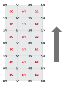
The arrow indicates the direction of travel.
| Attribute Name | Type | Description |
|---|---|---|
numberOfColumns
|
int
|
Number of storing positions in driving direction. |
numberOfRows
|
int
|
Number of storing positions perpendicular to the driving direction. |
wallElements
|
WallElement[]
|
Wall elements that are available for the vehicle configuration. Removable wall elements may be ignored in the resulting vehicle layout (required). |
coolingUnits
|
CoolingUnit[]
|
Cooling units that are available to refrigerate specific zones (optional). |
zones
|
Zone[]
|
Zones that will be separated by walls in the resulting layout. For example zones for different temperatures (required). |
VehicleLayout
| Attribute Name | Type | Description |
|---|---|---|
walls
|
Wall[]
|
The positioning of the wall elements. Unused wall elements are not returned. |
Wall
| Attribute Name | Type | Description |
|---|---|---|
orientation
|
WallOrientation
|
Orientation of the wall. |
startPosition
|
Position
|
Position of the wall element in the wall grid. |
length
|
int
|
Length of the wall measured in grid units. |
WallElement
| Attribute Name | Type | Description |
|---|---|---|
orientation
|
WallOrientation
|
Orientation type of the wall element.
The default value is ROW. |
length
|
int
|
Length of the wall element measured in grid units. |
wallStartPositionBounds
|
WallPositionBounds
|
Describes possible wall positions by defining a range of start positions (required).
Column walls have to start at a single point. That means minimumRow = maximumRow and minimumColumn=maximumColumn for column walls. Row walls may only be moved in a specific column. That means minimumColumn = maximumColumn for row walls. |
removable
|
boolean
|
Indicates that a wall element is removable and therefore optional. Removable wall elements do not have to be considered when planning.
The default value is false. |
WallPositionBounds
Describes possible wall positions in the wall grid. Due to the fact that wall elements are not stretchable the bounds of the wall element are described by the starting position of the wall element relative to the origin of the wall grid.
Column walls have to start at a single point. That means minimumRow = maximumRow and minimumColumn=maximumColumn for column walls.
Row walls may only be moved in a specific column. That means minimumColumn = maximumColumn for row walls.
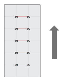
For example the red lines mark possible postions of a row wall with a length of one. The positions are labeled row / column.
| Attribute Name | Type | Description |
|---|---|---|
minimumColumn
|
int
|
Minimal start column of the wall element in the wall grid. 0/0 is the front left corner in driving direction. |
maximumColumn
|
int
|
Maximum start column of the wall element in the wall grid. 0/0 is the front left corner in driving direction. |
minimumRow
|
int
|
Minimal start row of the wall element in the wall grid. 0/0 is the front left corner in driving direction. |
maximumRow
|
int
|
Maximum start row of the wall element in the wall grid. 0/0 is the front left corner in driving direction. |
Zone
| Attribute Name | Type | Description |
|---|---|---|
id
|
String
|
The unique identifier of the zone representing its characteristics. Duplicate identifiers will cause an exception (required). |
requiresCoolingUnit
|
boolean
|
Indicates if a cooling unit is needed for this zone. |
ZoneLoadingPlan
| Attribute Name | Type | Description |
|---|---|---|
vehicleLayout
|
VehicleLayout
|
Layout of the vehicle walls. |
transportUnitAssignments
|
TransportUnitAssignment[]
|
Assignment of the planned transport units to storing positions in the loading space. |
ErrorCode
| Enumerator Name | Value | Description |
|---|---|---|
LICENSE_ERROR
|
10000 |
License is not valid or expired. |
REQUIREDPARAMETER_ERROR
|
10001 |
Missing a required input parameter. |
INVALIDPARAMETER_ERROR
|
10002 |
A parameter was set to an invalid value. |
MODULE_ERROR
|
10003 |
General error code of the xload module. |
ENGINE_ERROR
|
10004 |
Engine call returned an error. |
WallOrientation
| Enumerator Name | Value | Description |
|---|---|---|
ROW
|
None | Represents a wall oriented perpendicular to the driving direction. |
COLUMN
|
None | Represents a wall oriented along the driving direction. |
XLoadException
common


BoundingBox
| Attribute Name | Type | Description |
|---|---|---|
leftTop
|
Point
|
The left top corner point. |
rightBottom
|
Point
|
The right bottom corner point. |
BulkProgress
Extends JobProgress
| Attribute Name | Type | Description |
|---|---|---|
remaining
|
int
|
Specifies how many requests have still to be calculated. |
successful
|
int
|
The number of successful calculations so far. |
failed
|
int
|
The number of failed computations so far. |
ClusterProgress
Extends JobProgress
| Attribute Name | Type | Description |
|---|---|---|
action
|
String
|
The current action being executed. For more information on progress see About Asynchronous Protocol. |
distanceMatrixProgress
|
DistanceMatrixProgress
|
The progress of the distance matrix calculation, available only if action equals "DistanceMatrix.Calculation". |
optimizationProgress
|
OptimizationProgress
|
The progress of the optimization, available only if action starts with "Optimization.". |
DistanceMatrixCalculationProgress
| Attribute Name | Type | Description |
|---|---|---|
dimaId
|
int
|
The unique key to identify the distance matrix currently being calculated. |
currentDimaIndex
|
int
|
The 1-based index of the distance matrix currently being calculated. Depending on the number of different vehicles in the request the number of distance matrices to be calculated can be greater than |
lastDimaIndex
|
int
|
The index of the last distance matrix to be calculated, that is the total number of distance matrices. |
currentDistanceMatrixProgress
|
DistanceMatrixProgress
|
The progress of the distance matrix currently being processed, available only if action equals "DistanceMatrix.Calculation". |
DistanceMatrixProgress
Extends JobProgress
| Attribute Name | Type | Description |
|---|---|---|
currentRowIndex
|
int
|
The 1-based index of the current row of the current distance matrix being calculated. |
lastRowIndex
|
int
|
The index of the last row of the current distance matrix to be calculated. |
EncodedGeometry
Extends EncodedGeometryBase
The abstract base class for geometry objects used in a geographical PTV xServer. Contains the attributes to represent openGIS conform encodings with a specific coordinate format. The actual representation is defined by the CallerContext ResponseGeometry property (GeometryEncoding) and the CallerContext CoordFormat property (CoordFormat).
| Attribute Name | Type | Description |
|---|---|---|
wkb
|
byte[]
|
If not null, this attribute contains the well-known binary encoded form of the geometry |
wkt
|
String
|
If not null, this attribute contains the well-known text encoded form of the geometry |
kml
|
KML
|
If not null, this attribute contains the well-known text encoded form of the geometry |
EncodedGeometryBase
| No attributes defined. |
GeometryCollection
Extends EncodedGeometry
| Attribute Name | Type | Description |
|---|---|---|
geometryCollection
|
PlainGeometryCollection
|
If not null, this attribute contains the explicit form of the geometry |
ImprovementProgress
| Attribute Name | Type | Description |
|---|---|---|
availableMachineTime
|
int
|
The available machine time stated in the request in [s]. This value is 0 if available machine time is not set in the request. |
usedMachineTime
|
int
|
The machine time already used in [s]. |
iterationIndex
|
int
|
The index of this iteration. Index 0 denotes the initial plan directly after construction or the input plan. |
numberOfImprovements
|
int
|
The number of improvements the algorithm has already achieved. In other words, this is the number of tour plans with a smaller value of costOfObjectiveFunction than the best one at that time. |
currentPlan
|
KeyFigures
|
The key figures characterizing the current tour plan. |
bestPlan
|
KeyFigures
|
The key figures characterizing the currently best tour plan. |
initialPlan
|
KeyFigures
|
The key figures characterizing the initial tour plan. The initial tour plan is the input plan, if available, or the first tour plan after the construction step. |
Job
| Attribute Name | Type | Description |
|---|---|---|
id
|
String
|
This id references the background job on the server. |
status
|
JobStatus
|
The current status of the job. |
progress
|
JobProgress
|
The current progress of the job. Can be null at the very beginning or very end of the request execution. |
elapsedTime
|
int
|
Elapsed time since this job has been queued. |
JobProgress
| No attributes defined. |
KML
| Attribute Name | Type | Description |
|---|---|---|
kml
|
String
|
The KML string itself. |
placemarks
|
String[]
|
The placemarks of the KML. If empty, all placemarks will be used. This will result in a GeometryCollection, if more than one exists. |
KeyFigures
| Attribute Name | Type | Description |
|---|---|---|
costOfObjectiveFunction
|
int
|
The optimization aims at minimizing the objective function. This value contains its arithmetical cost. The significance of this value is not the value itself, but rather if and how fast it decreases during the calculation. The faster the value decreases the better the tour plans become according to the GoalImportance which defines what "better" means, at all. |
numberOfScheduledOrders
|
int
|
The number of orders already being scheduled. |
numberOfUnscheduledOrders
|
int
|
The number of orders not being scheduled, yet. These orders are feasible and can be scheduled during further improvement iterations. |
numberOfInfeasibleOrders
|
int
|
The number of orders not being scheduled. These orders are infeasible and will not be scheduled during further improvement iterations. |
numberOfScheduledVehicles
|
int
|
The number of vehicles being scheduled. |
totalTourCount
|
int
|
The number of all planned tours. |
totalTourPeriod
|
int
|
The sum of the tour periods for all planned tours ([sec]). |
totalTourDrivingPeriod
|
int
|
The sum of the tour driving periods for all planned tours ([sec]). |
totalTourWaitingPeriod
|
int
|
The sum of the tour waiting periods for all planned tours ([sec]). |
totalTourDistance
|
int
|
The sum of the tour distances for all planned tours ([m]). |
totalTourCost
|
int
|
The sum of the tour costs for all planned tours ([MU]). The costs per chain will not be included, see attribute totalChainCosts. |
totalChainCost
|
int
|
The sum of the costs per chain of all planned chains ([MU]). See VehicleCosts. |
totalChainPeriod
|
int
|
The sum of the chain periods of all planned chains ([sec]). The chain period is defined as the period between the start of the first tour and the end of the last tour. This period is greater than the sum of the periods of all tours if two subsequent tours do not start right after the other. |
LineString
Extends EncodedGeometry
A line string as specified by the openGIS standard.
See EncodedGeometry for possible representations.
| Attribute Name | Type | Description |
|---|---|---|
lineString
|
PlainLineString
|
If not null, this attribute contains the explicit form of the geometry. ATTENTION: Filled with requested EncodedGeometry representation (not necessarily a plain geometry). |
LinearRing
Extends EncodedGeometry
A linear ring as specified by the openGIS standard.
See EncodedGeometry for possible representations.
| Attribute Name | Type | Description |
|---|---|---|
linearRing
|
PlainLinearRing
|
If not null, this attribute contains the explicit form of the geometry. ATTENTION: Filled with requested EncodedGeometry representation (not necessarily a plain geometry). |
MultiLineString
Extends EncodedGeometry
See EncodedGeometry for possible representations.
| Attribute Name | Type | Description |
|---|---|---|
multiLineString
|
PlainMultiLineString
|
If not null, this attribute contains the explicit form of the geometry. ATTENTION: Filled with requested EncodedGeometry representation (not necessarily a plain geometry). |
MultiPoint
Extends EncodedGeometry
See EncodedGeometry for possible representations.
| Attribute Name | Type | Description |
|---|---|---|
multiPoint
|
PlainMultiPoint
|
If not null, this attribute contains the explicit form of the geometry. ATTENTION: Filled with requested EncodedGeometry representation (not necessarily a plain geometry). |
MultiPolygon
Extends EncodedGeometry
See EncodedGeometry for possible representations.
| Attribute Name | Type | Description |
|---|---|---|
multiPolygon
|
PlainMultiPolygon
|
If not null, this attribute contains the explicit form of the geometry. ATTENTION: Filled with requested EncodedGeometry representation (not necessarily a plain geometry). |
OptimizationProgress
| Attribute Name | Type | Description |
|---|---|---|
currentLoopIndex
|
int
|
The index of the current loop being calculated. |
lastLoopIndex
|
int
|
The index of the last loop being calculated. The calculation will automatically be finished by the algorithm before reaching this index when no improvement could be reached, anymore. The total number of loops can be set for the improvement step, only (see Params). |
progress
|
int
|
The progress in % of the current loop being calculated. |
PlainGeometryBase
| No attributes defined. |
PlainGeometryCollection
Extends PlainGeometryBase
| Attribute Name | Type | Description |
|---|---|---|
geometries
|
PlainGeometryBase[]
|
The set of geometries making up the geometry collection. |
PlainLineString
Extends PlainGeometryBase
A plain structured line string consisting of a set of points.
| Attribute Name | Type | Description |
|---|---|---|
points
|
PlainPoint[]
|
The set of points defining the line string. |
PlainLinearRing
Extends PlainGeometryBase
A plain structured linear ring consisting of a set of points
| Attribute Name | Type | Description |
|---|---|---|
points
|
PlainPoint[]
|
The set of points defining the linear ring. |
PlainMultiLineString
Extends PlainGeometryBase
| Attribute Name | Type | Description |
|---|---|---|
lineStrings
|
PlainLineString[]
|
The set of line strings making up the multi line string. |
PlainMultiPoint
Extends PlainGeometryBase
| Attribute Name | Type | Description |
|---|---|---|
points
|
PlainPoint[]
|
The set of points making up the multi point. |
PlainMultiPolygon
Extends PlainGeometryBase
| Attribute Name | Type | Description |
|---|---|---|
polygons
|
PlainPolygon[]
|
The set of polygons making up the multi polygon. |
PlainPoint
Extends PlainGeometryBase
A plain structured point consisting of two floating point attributes for the coordinates. In contrast to Point it is never transformed.
| Attribute Name | Type | Description |
|---|---|---|
x
|
double
|
The x coordinate |
y
|
double
|
The y coordinate |
z
|
Double
|
The z coordinate (optional, only if requested) |
PlainPolygon
Extends PlainGeometryBase
A plain structured polygon consisting of a set of linear rings.
| Attribute Name | Type | Description |
|---|---|---|
linearRings
|
PlainLinearRing[]
|
The set of linear rings making up the polygon. |
PlanProgress
Extends JobProgress
| Attribute Name | Type | Description |
|---|---|---|
action
|
String
|
The current action being executed. For more information on progress information see About Asynchronous Protocol. |
distanceMatrixCalculationProgress
|
DistanceMatrixCalculationProgress
|
The progress of the distance matrix calculation, available only if action starts with "DistanceMatrix.". |
improvementProgress
|
ImprovementProgress
|
The progress of the improvement step during the tour plan optimization, available only if action equals "Optimization.Improvement". |
Point
Extends EncodedGeometry
Represents a single coordinate (point). Do not use this type for other points (e.g. pixel in an image), the coordinates are automatically transformed. Instead use PlainPoint.
See EncodedGeometry for possible representations.
| Attribute Name | Type | Description |
|---|---|---|
point
|
PlainPoint
|
If not null, this attribute contains the explicit form of the geometry. ATTENTION: Filled with requested EncodedGeometry representation (not necessarily a plain geometry). |
Polygon
Extends EncodedGeometry
A polygon as specified by the openGIS standard.
See EncodedGeometry for possible representations.
| Attribute Name | Type | Description |
|---|---|---|
polygon
|
PlainPolygon
|
If not null, this attribute contains the explicit form of the geometry. ATTENTION: Filled with requested EncodedGeometry representation (not necessarily a plain geometry). |
RequestOptions
General options for requests
| Attribute Name | Type | Description |
|---|---|---|
coordFormat
|
CoordFormat
|
The coordinate format used in the request/response. |
responseGeometry
|
GeometryEncoding[]
|
The geometry encoding for the response. |
profile
|
String
|
The name of the parameter profile to be used. |
profileXMLSnippet
|
String
|
For internal use only. |
srId
|
String
|
If the coordFormat equals to 'OG_SRID', this attribute contains the Spatial Reference Identifier as specified by the Open Geospatial Consortium (OGC), otherwise it is null. All codes of the EPSG Geodetic Parameter Dataset V7.9 maintained by the EPSG. |
TerritoryProgress
Extends JobProgress
Implementation of JobProgress for territory planning.
| Attribute Name | Type | Description |
|---|---|---|
action
|
String
|
The current action being executed. For more information on progress with territory planning see the use case documentation. |
distanceMatrixProgress
|
DistanceMatrixProgress
|
The progress of the distance matrix calculation, available only if action equals "DistanceMatrix.Calculation". |
optimizationProgress
|
int
|
The progress of the optimization, available only if action starts with "TerritoryOptimization.". |
WatchOptions
| Attribute Name | Type | Description |
|---|---|---|
progressUpdatePeriod
|
Integer
|
If defined this optional parameter enables additional progress updates with the specified interval. If no new progress update arrives during the specified period, watchJob will wait for and return with the next available progress update. Important updates such as terminal states will always return immediately. The minimum period must be at least 250ms. If no progress waiting period is defined, progress will only be sent as part of status updates. |
maximumPollingPeriod
|
Integer
|
Specifies the timeout after which watchJob will report the last status even if no further updates are available.If not specified a configured default is used. |
ZoneLoadingProgress
Extends JobProgress
| Attribute Name | Type | Description |
|---|---|---|
action
|
String
|
The current action being executed. |
optimizationProgress
|
int
|
The progress of the optimization, available only if action starts with "LoadingSpaceOptimization.". |
CoordFormat
The CoordFormat enumeration contains all coordinate types supported by the PTV xServer. All examples represent the same geographic location.
| Enumerator Name | Value | Description |
|---|---|---|
OG_GEODECIMAL
|
None |
OpenGIS representation of WGS 84 coordinates. Example x=8.2505556, y=48.7627778. |
PTV_MERCATOR
|
None | Mercator projection. Example x=917420, y=6227729. |
PTV_GEOMINSEC
|
None |
PTV representation of coordinates by degree, minute, and second. Example x=815020, y=4845460. |
PTV_GEODECIMAL
|
None |
PTV representation of WGS 84 coordinates. Example x=825056, y=4876278. |
PTV_CONFORM
|
None |
PTV representation of conform coordinates. Example x=1672358, y=1620743. |
PTV_SUPERCONFORM
|
None |
PTV representation of super-conform coordinates. Example x=5072358, y=3320743. |
PTV_SMARTUNITS
|
None |
PTV internal coordinate format. Example x=4352286, y=5456405. |
OG_SRID
|
None |
This format is set implicitly, if a Spatial Reference Identifier as specified by the Open Geospatial Consortium (OGC) is set in the CallerContext. All codes of the EPSG Geodetic Parameter Dataset V7.9 maintained by the EPSG.. |
ErrorCode
| Enumerator Name | Value | Description |
|---|---|---|
REQUEST_INVALID_WKT
|
10 |
The specified WKT in the request is invalid. It should a well-known text representation of a geometry from a string (see the OpenGIS simple features specification). |
REQUEST_INVALID_WKB
|
11 |
The specified WKB in the request is invalid. It should be a geometry from a byte stream in well-known binary format. |
REQUEST_INVALID_KML
|
12 |
The specified KML in the request is invalid. |
KML_PLACEMARK_NOT_FOUND
|
13 |
Thrown, if requested placemark name is not found in the KML |
CONVERT_GEOMETRY_OBJECT
|
20 |
One or more geometry objects in the request are invalid. There are problems to convert a geometry object to a plain geometry object. Also used for retrieving the plain geometry object from a geometry object. |
CONVERT_COORDINATE_FORMAT
|
21 |
There are problems to convert a CoordFormat of the request to a coordinate type. |
GEOMETRY_ENCODING
|
22 |
Geometry objects cannot be encoded. |
GeometryEncoding
Defines encoding options for geometry parameters and results.
Plain indicates that geometry objects should be transmitted in plain object form, WKB indicates that openGIS well-known binary format should be used, WKT represents the openGIS well-known text format. KML represents the Keyhole Markup Language.
| Enumerator Name | Value | Description |
|---|---|---|
PLAIN
|
None |
Plain geometry encoding using structured objects and according network presentation. |
WKB
|
None |
Geometry should be represented by well-known binaries. |
WKT
|
None |
Use well-known texts to encode geometry objects. |
KML
|
None |
Use Keyhole Markup Language to encode geometry objects. |
JobStatus
| Enumerator Name | Value | Description |
|---|---|---|
QUEUING
|
None |
Job has been enqueued. |
RUNNING
|
None |
Job is currently running. |
STOPPING
|
None |
Stop has been requested, the job will terminate its calculation as soon as possible. |
SUCCEEDED
|
None |
Job has completed successfully. |
FAILED
|
None |
Job has failed with an exception. |
DELETED
|
None |
The job was deleted by the user. |
UNKNOWN
|
None |
The job is in an unknown state. For example a given id is unknown or the job has already been fetched and has thus been deleted from the underlying persistent store. |
XServiceException
SystemException (from package com.ptvag.jabba.core.exception)
Copyright © 2025 PTV Logistics GmbH All rights reserved. | Imprint