About Geographical and Map Topics
Visualising spatial information and performing geographical
analyses are basic functions for the most of the PTV xServer use
cases. This page contains several geographical and map topics.
- Coordinate Systems and Map Projections
- Airline distance calculations
- Using multiple PTV xServer and PTV Maps
Coordinate Systems and Map Projections
PTV Coordinate Formats
The PTV xServer currently support the following coordinate
formats:
| OG_GEODECIMAL |
Geographic Coordinates in decimal degree notation (WGS84, EPSG:4326) |
49.013106, 8.427825 |
| PTV_MERCATOR |
PTV variant of Mercator
projection: cylindrical map projection |
6270051, 937090 |
| PTV_GEOMINSEC |
PTV variant of
Geographic Coordinate in degree notation (WGS84) |
49°0'47.182'', 8°25'40.17'' |
| PTV_GEODECIMAL |
PTV c type variant of
Geographic Coordinates in decimal degree notation (WGS84) |
4901310.6, 842782.5 |
| PTV_SMARTUNITS |
PTV internal
coordinate format of the Smart Data format (do not use it!) |
5465209, 4356385 |
Coordinate format conversion
This section aims at providing information on how to convert
coordinates from one format to another. In the table below, you can
see the coordinates of some locations in different formats.
As you can imagine, each of these conversions is proceeded by
using specific formula in background. Let us take a look at some of
them.
Input: ( XM, YM ) coordinates of the given point in Mercator
format.
Output: ( XGD, YGD ) coordinates in Geodecimal format.
We have:
( XGD, YGD ) = ( λ , φ ) x 100000, where
-
λ = (180 / π) x (XM / 6371000), and
-
φ = (180 / π) x (Arctan(exp(YM / 6371000)) - π/4) x 2
|
Input: ( XGD, YGD ) coordinates in Geodecimal format.
Output: ( XM, YM ) coordinates in Mercator format.
We have:
( XM, YM ) = ( XRes, YRes ), where
XRes = 6371000 x (π/180) x λ, and
YRes = 6371000 x ln(tan(π/4 + π/180 * φ/2)) , with
( λ,φ) = ( XGD, YGD ) / 100000
|
 C# sample
A typical conversion in the program would look like this where the
invoked method Mercator_2_GeoMinSec(arg1,arg2,arg3,arg4)
will compute the coordinates in the new format.
long xOut, yOut;
   // Calling the actual conversion method which
   // returns the rounded integer values of the
   // transformed coordinates in (xOut, yOut)
   int result = Mercator_2_GeoMinSec((long)1110032, (long)7076381, out xOut, out yOut);
   Console.WriteLine("Mercator: 1110032, 7076381");   // Hamburg Mercator coordinates
   Console.WriteLine("To GeoMinSec: " + xOut.ToString() + ", "
 + yOut.ToString()); // 958579 , 5332392
Java sample
A typical conversion in the program would look like this where the
invoked method Mercator_2_GeoMinSec(arg1,arg2) will
compute the coordinates in the new format.
long[] result = Mercator_2_GeoMinSec((long)1110032, (long)7076381);
System.out.println("Mercator: 1110032, 7076381");
System.out.println("To GeoMinSec: " + result[0] + "; " + result[1] + "\n");
Airline Distance Calculations
If you want to use PTV xMap Server to display points of interest
(POI) on a PTV map (e.g. European City Map Premium, North America City
Map, World Map, etc.) you usually store the POIs in a database and
provide PTV xMap Server only with those points which are in the
currently displayed map segment or in an otherwise defined region of
interest (ROI).
The examples below show you how to use standard SQL to select POIs
from a database table which lie in a given
rectangle or within an airline
distance from a given point.
Retrieving
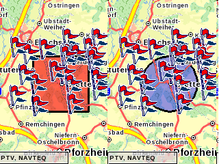
points within rectangular bounds
If you have a region specified by bounds you can use the BETWEEN
statement as shown below in order to retrieve the POIs within that
region. As shown in the first mapping example, PTV xMap Server
provides you with the map's bounding rectangle, which can be used to
obtain the values for the SQL statement below (e.g. left-top
[960000,6280000] and right-bottom [970000,6260000]).
SELECT * FROM points WHERE
  x BETWEEN  (950000) AND  (970000)
  AND y BETWEEN (6260000) AND (6280000);
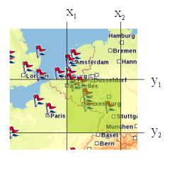
In case you have the region is given by a center coordinate
(e.g. [960000, 6270000]) and a region size (e.g. 40000x30000) you can
also use the the following query:
SELECT * FROM points WHERE
 ABS(x-960000) < 20000 AND ABS(y-6270000) < 15000;
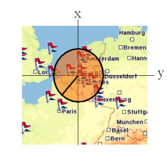
Retrieving
points within an airline distance / circular bounds
If you have a region specified by centre coordinates and a given
radius (all points in a radius of 10,000 Mercator units) you can use
the below defined formular.
SELECT * FROM points WHERE
 (x-960000)*(x-960000)+(y-6270000)*(y-6270000) < (10000*10000)
Distance calculation with Mercator coordinates
In the SQL statements above all values are Mercator values, but
often you want to use values in meters to specify or calculate
distances. Below, we show you how to calculate the airline distance
between two Mercator coordinates.
The function below uses a formula which gives an
approximation of the distance in meters. Hence, the result is not
exact, but for distances up to 600 km and 80° latitude the error is
sufficiently small.
public static double distanceFromMercator(double x1, double y1, double x2, double y2) {
   double dx = x2 - x1;
   double dy = y2 - y1;
   double Y, B, distance;
   Y = 0.5 * (y2 + y1);
   B = 2.0 * Math.atan(Math.exp(Y / 6371000.0)) - (0.5 * Math.PI);
   distance = Math.cos(B) * Math.sqrt(Math.pow(dx, 2) + Math.pow(dy, 2));
   return distance;
 }
Calculate reachable objects
We simply showed how to use the calculateReachableObjects
function in order to find out which locations are reachable within a
certain time or distance domain considering the given routing options.
But if you have thousands of POIs it would be impractical to load all
points in the database. But you are able to decrease the number of
points using the SQL-statements as mentioned above.
For example, if you want to find out which objects are reachable
within a 10 minute drive you will receive all points from the database
which are within 25 km radius. This airline distance is calculated
provided that your speed is 150 km/h. Afterwards you would fill the
input list with the selection of points instead of all points in the
database.
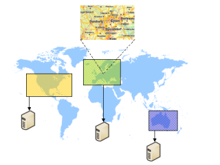
Using multiple PTV xServer and PTV Maps
A PTV xServer installation is always configured to use one
distinct map. But sometimes you want to handle requests where each
request targets a region in a different map. For example, you provide
a store locator for your customers and you have stores all over the
world. In this case you would have multiple PTV xServer installations
each handling requests using a different map (e.g.: Europe City Map
Premium, North America City Map, Australia City Map, etc.).
In this example we show you how to get the right server for a
given point or rectangle (which is the server having the most detailed
map for the region that contains the point or rectangle).
When geocoding addresses you usually know the
country the address is located in. So this case is easy to handle with
an associative array which maps countries to servers. Hence, we do not
describe this scenario below.
Setting up the Region Directory
A region directory returns the ServerRegion for a given point
(or rectangle) which contains the point. If the point is contained in
multiple regions, the supplied IServerRegionComparer is used to
determine which region has a higher rank and should come first. In our
case we use the detail level of the map that covers a region to
determine which region to return.
C# Sample
IRegionDirectory<StandardServerInfo directory> = new
   SimpleRegionDirectory<StandardServerInfo>(
   delegate(ServerRegion<StandardServerInfo> a,
   ServerRegion<StandardServerInfo> b) {
   return a.ServerInformation.MapDetail -
   b.ServerInformation.MapDetail;
 });
Java Sample
IRegionDirectory<StandardServerInfo> directory = new
   SimpleRegionDirectory<StandardServerInfo>(
   new IServerRegionComparer<StandardServerInfo>(){
   @Override
   public int compare(ServerRegion<StandardServerInfo> a,
   ServerRegion<StandardServerInfo> b) {
   return a.getServerInformation().getMapDetail() -
   b.getServerInformation().getMapDetail();
   }
 });
Adding Regions
In order to add a region to the directory you have to create a new ServerRegion<StandardServerInfo>
by specifying the left, right, bottom and top bounds. Afterwards you
add information about which server to use for the region, and add the
region to the directory.
C# Sample
// create a new region
   ServerRegion<StandardServerInfo> regionGermany =
   new ServerRegion<StandardServerInfo>(663234, 1665183, 6028293, 7316753);
   // add information to the region
   regionGermany.ServerInformation = new StandardServerInfo();
   regionGermany.ServerInformation.MapDetail = 3;
   regionGermany.ServerInformation.XmapUrl = "http://localhost:50010/xmap/ws/XMap";
   // add the region to the directory
 directory.addRegion(regionGermany);
Java Sample
// create a new region
   ServerRegion<StandardServerInfo> serverGermany
   = new ServerRegion<StandardServerInfo>(663234,1665183,6028293,7316753);
   // add information to the region
   StandardServerInfo serverInfoGermany = new StandardServerInfo();
   serverInfoGermany.setMapDetail(3);
  serverInfoGermany.setXmapUrl("http://localhost:50010/xmap/ws/XMap");
   serverGermany.setServerInformation(serverInfoGermany);
   // add the region to the directory
 directory.addRegion(serverGermany);
Getting the Right Server
Once your region directory is set up, you can use it to determine the
right server for a request. In the example below, we use the bounding
box to request the region from the directory. The returned region
contains the information we entered earlier. In this case we use the xmapUrl
from the server information to initialise the SOAP client class.
C# Sample
ServerRegion<StandardServerInfo> region = directory.getRegion(boundingBox);
   if (region != null) {
   XMapWSService xmapClient = new XMapWSService();
   xmapClient.Url = region.ServerInformation.XmapUrl;
   // ...
 }
Java Sample
ServerRegion<StandardServerInfo> region = directory.getRegion(boundingBox);
   if (region != null) {
   XMapWS xmapClient = new XMapWSProxy( region.getServerInformation().getXmapUrl() );
   // ...
   Map map = xmapClient.renderMapBoundingBox(boundingBox, mapParams, imageInfo,
   null, false, null);
 }
Information about coordinate formats and the definition of bounding
boxes are also available in this documentation. The bounding box is
defined by the map corners "left top" and "right bottom".
Code Samples
These and other samples are also available as
stand-alone java and C# programs.
Copyright © 2025 PTV Logistics GmbH All rights reserved. | Imprint