The PTV xServer Family
PTV xServer
PTV xLocate Server

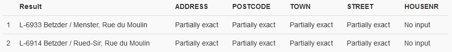
Our specialist for geocoding, reverse geocoding and simple
nearest searches (based on airlines). Within the geocoding context we
provide fault-tolerant searches (phonetic and fuzzy) and international
address labels. Suggestion search (auto-completion) is integrated as a
new function.
 More details
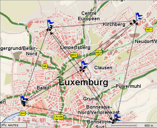
The PTV xLocate Server finds the geographic coordinates for
addresses (geocoding) or provides the addresses that are closest to
geographic coordinates (reverse geocoding). The results obtained
with the PTV xLocate Server can be used for further processing in
other applications, e.g. with other PTV xServer. For instance, the
data will be shown in the form of addresses on a digital map, used
as a start, via or destination point for route calculation.
Moreover, the PTV xLocate Server can be used to search for
POIs that are close to a coordinate.
The PTV xLocate Server is a software component, i.e. it has
interfaces that allow the transfer of data to the PTV xLocate
Server, call functions and transfer results back to another system.
The PTV xLocate Server can be integrated into your existing
application environment.
The big five
- Address classification: Use the additional fields to
validate your candidates in relation to the input or put your
result in an order according to the total score.
- Batch geocoding: Define the locations for a huge amount of
addresses in one call in order to update your specific address
database.
- Reverse geocoding: List the best candidates depending on
town categories (capital city, big, medium or small cities etc.).
- Fuzzy search: Consider misspelling and find the correct
address.
- Choose between multi- and single-field search.
PTV xRoute Server

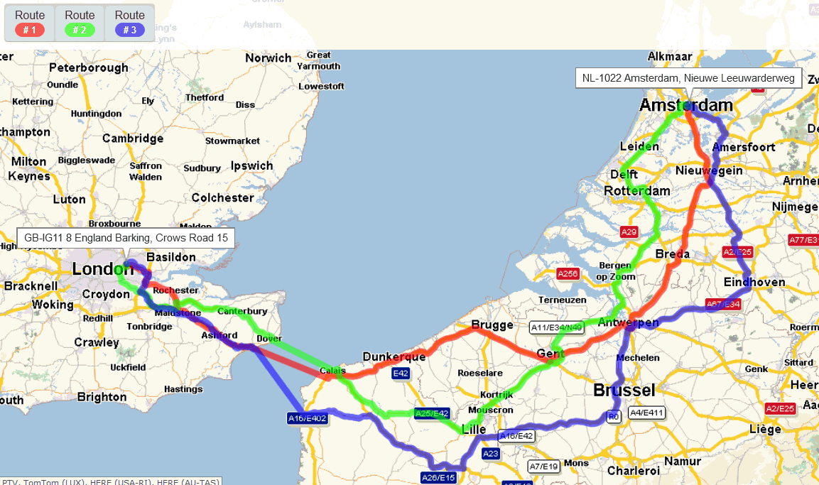
Provides flexible access to our routing algorithms for usage
within multi-station routing, matrix computation, nearest and corridor
search and isochrones (=areas of reachability). Returns turning
directions, international toll, emission, driving time and distance
based on your vehicles properties such as speed values, avoidance
behaviour, emission class, weight, height and many more. Use of
ferries and piggybacks as waypoints is a new element of PTV xRoute
Server. PTV therefore offers a new function to calculate combined
transport in route planning.
More details
The PTV xRoute Server calculates routes between several points
for further use in other applications. The routes are generally
provided via network connections. The digital maps are based on PTV
map material.
The PTV xRoute Server is deployed where distances, driving
times or route costs must be calculated. Live traffic information,
traffic patterns, toll scenarios and emissions (HBEFA 3.1) can be
taken into account. Furthermore, functionalities like RoadEditor,
combined transports, isochrones calculation with time-distance
events and matrices computations are part of PTV xRoute Server.
The PTV xRoute Server is a software component, i.e. it has
interfaces that allow the transfer of data to the PTV xRoute Server,
call functions and transfer results back to another system.
The PTV xRoute Server can be integrated into your existing
application environment.
The big five
- Dynamic routing: Calculate alternative routes according to
the historical traffic information based on FCD or actual traffic
incidents via TomTom HD Traffic.
- Benefit from PTV's premium data such as tolls, truck
attributes, emissions, preferred routes and much more.
- Define your specific vehicle profiles (car or truck) to
receive the best routing results.
- Calculate your tour taking your driver regulations into
account.
- Define your corridor along a route and add all reachable
objects according to time or distance.
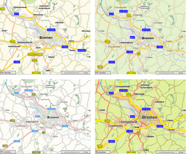
PTV xMap Server

Renders customisable maps displaying geographic-related data
such as points of interest, routing polygons and areas. Enables
flexible zooming, panning and centring of areas. We also offer a
licence model to use satellite imagery from here in combination with
PTV maps.
More details
The PTV xMap Server uses digital maps to create map sections
for further use in other applications. The map sections are
generally provided via network connections. The PTV xMap Server
interacts with other applications: This allows users to enlarge
maps, move them, etc. The digital maps are based on PTV map
material.
The map sections created are defined by:
The PTV xMap Server is deployed (frequently together with
other PTV xServer) where information must be displayed on a map:
e.g. customer addresses, locations, routes, vehicle positions or
sales territories.
The PTV xMap Server is a software component, i.e. it has
interfaces that allow the transfer of data to the PTV xMap Server,
call functions and the transferring of results back to another
system.
The PTV xMap Server can be integrated into your existing
application environment.
The maximum default image size is 3840 x 2400 (4 x 1920 x
1200).
The big five
- Design your own map profile.
- Profit from "on-the-fly" rendering at considerable speed.
- Draw all specific data content such as routings, municipal
boundaries, LOS (level of service regarding the traffic flow),
preferred routes, customer specific objects etc. onto your map.
Select between server- and client-side drawing.
- Use the international codes drawing the country specific
characters (Cyrillic, Greek characters etc.).
- Integrate map controls such as AJAX Maps or frameworks such
as PTV xServer .NET to interact with the PTV xMap Server.
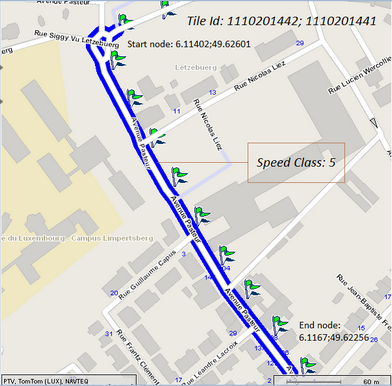
PTV xMapmatch Server

Links GPS tracks to the corresponding street network segments.
Required for target performance comparison (examine toll or emission
costs using PTV xMapmatch Server in combination with PTV xRoute
Server). Returns a list of speed limits and network classes if
required. Total distance and period are also supplied.
More details
The PTV xMapmatch Server matches a list of geocoordinates (aka
a track) to a given map, thus connecting the input positions to the
given road network. The results obtained with PTV xMapmatch Server
can be used for further processing in other applications, e.g. with
other PTV xServer. For instance, it is possible to show the data in
the form of a list of segments on a digital map, or use it to verify
where exactly a specific vehicle was driving.
The PTV xMapmatch Server is a software component, i.e. it has
interfaces that allow transferring data to the PTV xMapmatch Server,
call functions and transfer results back to another system.
The PTV xMapmatch Server can be integrated into your existing
application environment.
The big five
- Match the exact route from your GPS trace.
- Check your speed in comparison to the legal rules.
- Switch between local (matching without considering previous
positions) and global mode (consider historical data/GPS
positions).
- Pay as you drive: local matching and data processing in
view of real distance driven.
- Fleet management solution: match and post data processing
in your own data center. Detailed cost analysis by using PTV xRoute
Server for target/actual comparison.
PTV xDima Server

A stateful server for quick computation of large distance
matrices with distances and driving times between user-defined
locations. Considers truck attributes and different vehicle profiles.
More details
The PTV xDima Server calculates distances and driving periods
between many different locations. The calculation results are in the
form of distance matrices. These matrices store the calculated
routing results and can be called up from other systems without the
need to calculate the routes again.
A distance matrix consists of the following elements:
-
Locations
A location is a geographical point. The position
is described by x and y coordinates of the relevant planning
objects.
-
Distance tableA distance table contains the distances and
driving periods between all locations included in the distance
matrix. These data are persistent and can be extended with
distances and driving periods between additional locations if
required.
-
Profile
A profile consists of the distance calculation
settings, such as the vehicle type or speed configurations.
This is important, for example in the case of an optimisation
problem like trip planning. The distances and driving periods
between the planning objects like depots or customers are called up
millions of times by the algorithms. A pre-calculated distance
matrix reduces the calculation time enormously.
PTV xDima Server
-
calculates and manages distance matrices efficiently
-
provides fast access to distances and driving periods
between different locations
-
imports distance matrices from external sources to use them
in PTV products
-
exports distance matrices that can be used by other systems
without the need to access PTV xDima Server
The PTV xDima Server is a software component, i.e. it has
interfaces that allow the transfer of data to the PTV xDima Server,
call functions and transfer results back to another system.
The PTV xDima Server integrates into your existing application
environment.
Please note that the distance table does not include detailed
route descriptions like polygons.
The PTV xDima has been developed to calculate distances and
driving periods between many different locations efficiently. In
doing so, the calculation considers the selected routing parameters
(e.g. the vehicle profile or the speed profile). The result of the
calculation is a quadratic nxn matrix.
This matrix is permanently stored on the hard disk. So you
have access to the distances and driving periods between the
locations at any time, even after a restart of the PTV xDima Server.
The PTV xDima Server is therefore a stateful server.
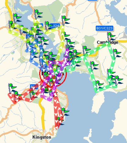
PTV xCluster Server

Divides existing orders or customer calls into homogeneous area
clusters. This is particularly useful for customers who are called
upon several times within the planning period. The groups are put
together using the geographical area and other criteria such as the
call duration so that a perfect utilisation of personnel and fleet
with an optimum customer call frequency is achieved.
More details
A service for clustering a certain number of orders according
to the defined rules (number of clusters to be created, considering
weekday patterns or multi week rules). The order contains a set of
parameters to define various values such as quantity, location,
visits per week or weekly rhythm. Furthermore, the order contains
one or more visits in compliance with the selected method. The
following methods are selectable to fullfil various requirements:
| Basic: plan
clusters |
A set of
orders will be clustered according to the defined number of
clusters. An order corresponds to one visit. The clustering
performs the best compactness and best balance of the total
quantity (potential value such as service period or turnover) for
each cluster. |
| Advanced:
plan visits for one week |
A set of
visits will be clustered for one week according to the specified
weekday patterns. An order contains one or more visits within
that week. Each visit is therefore assigned to one weekday. |
| Advanced:
plan visits for more than one week |
A set of
visits will be clustered for multi-week according to the weekly
rules. Again, an order contains one or more visits within these
weeks. Each visit is therefore assigned to one day and every day
corresponds to one cluster. |
PTV xTour Server

Used for construction and improvement of tour plans based on a
large number of transport orders, vehicles and depots. It considers
time limits, opening hours, breaks and much more. New functionalities
like train trailer combinations, hierarchical priority planning or use
of multi-distance matrices are implemented for complex tour planning.
More details
A tour is usually depot-related, that means a vehicle starts
at a depot, then serves transport orders and finally returns to a
depot. Besides the planning of round tours more tour structures like
start-depot-free tours are possible. Furthermore the planning
considers multiple depots, so the PTV xTour Server assigns transport
orders to depots and groups the orders to vehicle tours. After that,
the sequence of the orders within the vehicle tours is calculated.
During the optimisation, there are a lot of restrictions to
consider: Vehicle capacities and equipment, trailer and trains,
customer and depot opening hours, dynamic loading period
calculation, break and rest rules, additional break intervals, tour
limits like a maximum transport order count, transport order
priorities and product incompatibility to mention a few examples.
The tour planning algorithm permanently needs the distances
and driving periods between all locations. As it is too time
consuming to calculate the routes again and again in every planning
step, the PTV xTour Server creates a distance matrix immediately
before the tour planning and stores it on the hard drive.
The PTV xTour Server is a software component, i.e. it has
interfaces that allow the transfer of data to the PTV xTour Server,
call functions and transfer results back to another system. The PTV
xTour Server can be integrated into your existing application
environment.
The big five
- Select between sequence and tour optimisation considering
several constraints such as time windows, driver regulations,
capacities etc. Take the rest and break rules into account in line
with the EU or German regulations.
- Use high-performance routing for fast distance matrix
calculations which are the basis for any tour planning.
- PTV provides a set of heuristics to plan and optimise the
complex requirements of a tour (planning in the open countryside,
considering an input plan, area planning, balancing etc.), and give
results near to the optimum solution.
- Use the proposal functions to receive a computed proposal
for several use cases, such as to find the right vehicles for a
tour or the best matching tours for one vehicle.
- Calculate overnight tours based on a single vehicle.
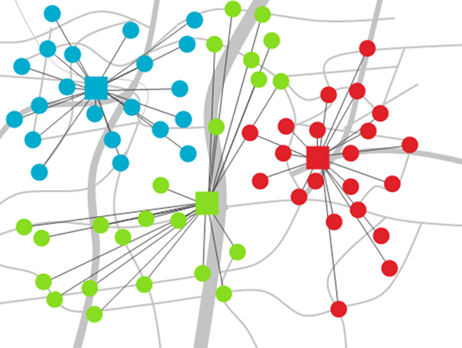
PTV xTerritory Server

This component provides methods to efficiently generate compact
and coherent clusters. In this way, customer locations can be quickly
assigned in a six-digit order to any number of areas. Thereby,
activity measurements are included, e.g. technician times or sales
expectations, producing the best possible rate between optimal
compactness and balanced areas in accordance with the determined
potential values.
More details
The big five
- Calculate a desired number of clusters in accordance with
the specified locations. In this way, large amounts of data are
processed efficiently and quickly.
- Add the customer locations, thereby calculating new areas,
or fill in existing clusters.
- Please note the activity measurements and create compact,
coherent and balanced clusters.
- Use the free (CBC) or commercial solver (Gurobi) in order
to achieve either convenient or quick optimal territories.
- There are no limitations with regards to the planning size.
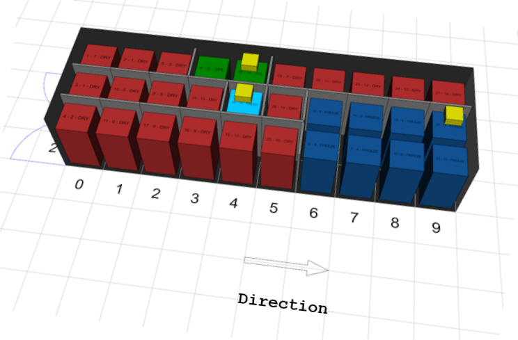
PTV xLoad Server

Optimising the cargo space is the main objective of the server.
The focus is placed on the optimal sequence in accordance with the
principle "last in, first out". Additionally, the following three
temperatures can be set: "dry, cooled and frozen". The truck cargo
space can be divided into different chamber zones using movable walls.
The above-mentioned limitations are considered in the plan.
More details
The big five
- The cargo space is optimised within a few seconds after the
route is planned.
- Find the suitable configuration in order to produce the
required temperature zones.
- Consider the order of the transported goods in accordance
with the principle "last in, first out".
- Configure the dimensions of your vehicle. In this case,
note the number of available containers and the number of required
chambers, taking the position of the cooling units into account.
- Map standard transport units, such as palettes or roll
containers.
PTV xServer Bundle
The PTV xServer bundle combines all PTV xServer services and
includes the PTV AJAX Maps add-on as well.
PTV xServer bundle deployment is simplified (e.g. there is only
one port) and memory requirements are reduced as there is only one web
server process.
PTV xServer .NET
PTV xServer .NET is an SDK which adds PTV xServer
functionalities to .NET client applications. The primary component is
the WPF map control which allows you to build interactive map
applications by using PTV xServer. While the technology of this
control is based on Windows Presentation Foundation, the SDK also
provides a FormsMap control for easy WinForms integration.
PTV xServer .NET provides a set of code samples on how to use
the map control, how to integrate the layer concepts such as shape
layer, custom layers, etc. It is also demonstrated to use several
layers (e.g. GeoRSS or WMS) to calculate routings or drawing satellite
images.
PTV xServer Add-Ons
AJAX Maps

A powerful servlet that enables you to easily include map
widgets in your web application and offers fine-grained control via a
powerful JavaScript interface. The PTV xServer add-on AJAX Maps is an
add-on to the PTV xMap Server. Please read the instruction manual
carefully.
Content Update Service
The PTV Content Update Service (CUS) enables additional data content to be automatically downloaded and provided.
A separate PTV Layer Delivery Server (LDS) provides current data such as toll updates and Traffic Incidents Feature Layer,
which is automatically downloaded via the CUS and can be used from a PTV xServer.
TrafficInfoLoader
A servlet that enables you to retrieve current traffic
information to display them on maps or to use them for routing
purposes i.e. avoiding jams or getting better travel times. The PTV
xServer add-on TrafficInfoLoader is an add-on to the PTV xRoute or
xMap Server by using the PTV OGC Traffic Service (providing traffic
incidents). It is highly recommended that the instructions are read
beforehand.
Caution:
The service "TrafficInfoLoader" is deprecated. PTV recommends
implementing Feature Layer theme "PTV_TrafficIncidents"
to obtain real-time traffic information for route planning. Benefit
from the time-dependent attributes!
Tools
Several tools covering programming, testing and configuration
management.
- PTV xServer request runner:
"XServerRequestRunner.class" is a Java class to run all requests
provided in a defined directory to benchmark your own hardware system
environment. SOAP-based request templates are available for the PTV
xLocate Server, PTV xMap Server and PTV xRoute Server at the
Developer Zone.
- PTV xMap Server test tool:
"xmap-test.exe" is a tool to navigate within the map and test certain
features (e.g. insert additional layers to the map). The tool
requires the PTV xMap Server.
- PTV xDima Server tester:
"xDimaTester.exe" is a tool to create, enhance and use distance
matrices with distances and driving times between user-defined
locations. The tool requires the PTV xDima Server.
- PTV xRoute Server BCR converter:
"BCRConverter-1.0.jar" is an easy-to-use Java class library to
convert a route calculated by PTV xRoute Server into a BCR formatted
string which can be used for guided navigation solutions.
Copyright © 2024 PTV Logistics GmbH All rights reserved. | Imprint