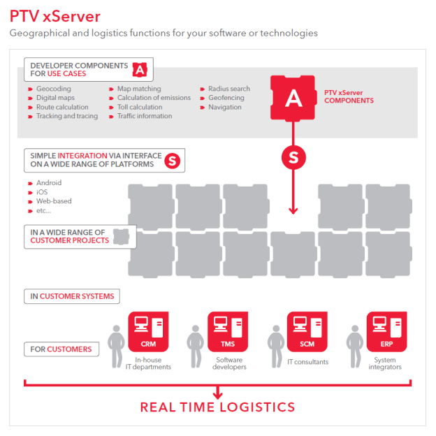
In PTV xServer, PTV provides the technology behind the PTV products in the form of efficient developer components, for your own applications and web services. These components integrate geographic and logistic functions into your software solutions. Integrating these components into your own applications or your company network is a quick and easy way to expand the range of functions, starting from simple track and tracing applications to complex planning scenarios. The PTV xServer is modular by design, which gives you a great opportunity to license functionalities according to your needs. Benefit from our many years of experience in digital map generation, geocoding, routing and solving complex planning tasks via PTV xServer.

Feature Layer (FL) architecture was developed in order to offer a wide variety of information to external providers in corresponding data layers for routing and rendering. The focus, on the one hand, is on being capable of processing huge amounts of data in the routing and rendering engines and, on the other hand, on allowing a wide variety of theme combinations. In the process, the prioritisation of layers, clarity of themes, ease of use through configuration and attention to time-dependent attributes played a major role. By using a unified architecture, it is now possible for PTV to meet the different requirements with regard to routing relevant information contained in the transport logistics. The following table provides information about the current Feature Layer topics that were introduced with version 1.17.
| Product | Version | Topic | Description |
|---|---|---|---|
| PTV xTour Server | 1.20 | Truck Attributes | Truck attributes can be enabled for route planning. |
| PTV xMap Server | 1.20 | Truck Attributes | Truck attributes can be represented in the configuration on a segment basis or as icons. PTV already provides a record to display the types accordingly. Note: Similar types are represented using the same icon. However, you can create your own icons and assign them to the respective types. |
| PTV xRoute Server | 1.20 | Truck Attributes | The Truck Attributes Layer is used to take the attributes into account when routing in accordance with the defined vehicle profile. PTV prepares this data. |
| PTV xMap Server | 1.20 | Traffic Information | Traffic information can be displayed as icons on a segment basis, depending on the zoom level. PTV readily provides a record to display the types accordingly. Note: Similar types are represented using the same icon. However, you can create your own icons and assign them to the respective types. |
| PTV xRoute Server | 1.20 | Traffic Information | The Traffic Information Layer can be used to take traffic into account when routing. In turn, you have the opportunity to use this data for static (specify the time delay, but stay on route in any case) or dynamic routing (alternative routes can be internally calculated and compared; the route with the lowest cost values is returned in accordance with the profile settings). PTV provides this data through the Traffic Information Service. |
| PTV xTour Server | 1.18.1 | Restriction Zones | The Restriction Zones can be enabled for route planning. |
| PTV xMap Server | 1.18.1 | Restriction Zones | Restriction zones are marked on a segment basis in accordance with the map configuration. Note: Spaces cannot be displayed. |
| PTV xRoute Server | 1.81.1 | Restriction Zones | The Restriction Zones Layer is used to consider blocked or limited spaces (e.g. Low Emission Zone in London) for certain types of vehicles in the route planning. PTV prepares these data. |
| PTV xTour Server | 1.18.1 | Time Zones | Time zones are enabled route planning. |
| PTV xTour Server | 1.18.1 | Preferred Routes | Preferred routes can be enabled for route planning. |
| PTV xMap Server | 1.18.1 | Preferred Routes | Preferred routes are displayed as colour-coded for corresponding segments in accordance with the configuration. |
| PTV xTour Server | 1.18.1 | Traffic Patterns | Traffic patterns can be enabled for route planning. |
| PTV xMap Server | 1.18.1 | Traffic Patterns | Traffic patterns can be displayed as a Level of Service (LOS) in the map. The traffic flow (e.g. flowing, faltering and coming to a standstill) is displayed in different colours on the segment (directional-related). The levels and colour values are configured accordingly. |
| PTV xRoute Server | 1.17 | Traffic Patterns | The Traffic Patterns Layer is used to take historical information into account in the route planning in regards to traffic flow speed. Depending on the time, the statistically calculated speed is determined on the segment and taken into account in the calculated time. You can choose between two options: Add time delay on the static route or calculate an alternative route (active dynamic routing). PTV prepares these data. |
| PTV xRoute Server | 1.17 | Preferred Routes | The Preferred Routes Layer is used to route is to preferred road segments. This normally applies to specific types of vehicles, e.g. trucks. PTV prepares these data. |
| PTV xRoute Server | 1.17 | Time Zones | The Time Zones Layer is used to correctly specify the time difference when passing from one zone to another. In this way, the time-dependent attributes can be used correctly and the arrival time is calculated as accurately as possible. Note: Time zones are not only considered in the routing. |
The Feature Layer themes are subject to licensing with the exception of "PTV_TimeZones".
Copyright © 2024 PTV Logistics GmbH All rights reserved. | Imprint